You are here: Home > Network List > IU - Global Seismograph Network (GSN - IRIS/USGS) Stations List
> Station CHTO Chiang Mai, Thailand > Earthquake Result Viewer
CHTO Chiang Mai, Thailand - Earthquake Result Viewer
| Earthquake location: |
Kuril Islands |
| Earthquake latitude/longitude: |
46.6/153.3 |
| Earthquake time(UTC): |
2006/11/15 (319) 11:14:13 GMT |
| Earthquake Depth: |
10 km |
| Earthquake Magnitude: |
6.5 MB, 7.8 MS, 8.3 MW, 7.9 MW |
| Earthquake Catalog/Contributor: |
WHDF/NEIC |
|
| Network: |
IU Global Seismograph Network (GSN - IRIS/USGS) |
| Station: |
CHTO Chiang Mai, Thailand |
| Lat/Lon: |
18.79 N/98.98 E |
| Elevation: |
316 m |
|
| Distance: |
52.2 deg |
| Az: |
256.854 deg |
| Baz: |
45.143 deg |
| Ray Param: |
0.06692508 |
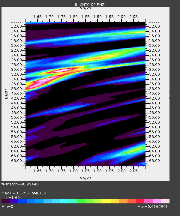
| Estimated Moho Depth: |
33.75 km |
| Estimated Crust Vp/Vs: |
1.69 |
| Assumed Crust Vp: |
6.35 km/s |
| Estimated Crust Vs: |
3.757 km/s |
| Estimated Crust Poisson's Ratio: |
0.23 |
|
| Radial Match: |
98.99446 % |
| Radial Bump: |
246 |
| Transverse Match: |
89.51948 % |
| Transverse Bump: |
400 |
| SOD ConfigId: |
590571 |
| Insert Time: |
2013-09-26 03:02:02.586 +0000 |
| GWidth: |
2.5 |
| Max Bumps: |
400 |
| Tol: |
0.001 |
|
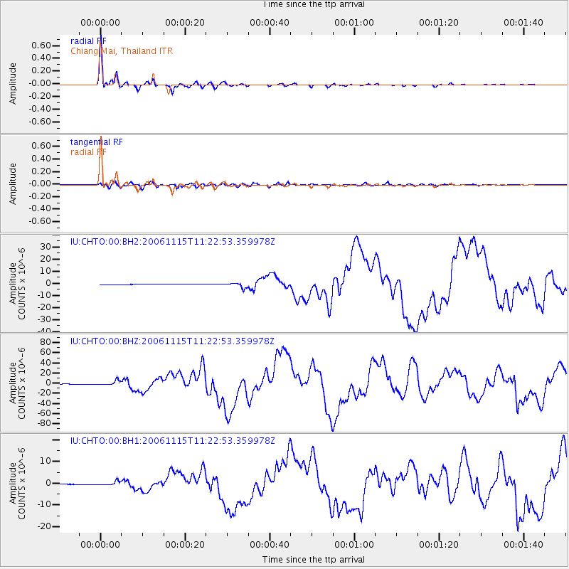
Signal To Noise
| Channel | StoN | STA | LTA |
| IU:CHTO:00:BHZ:20061115T11:22:53.359978Z | 11.354122 | 4.5170214E-6 | 3.9783095E-7 |
| IU:CHTO:00:BH1:20061115T11:22:53.359978Z | 5.8297644 | 9.1394E-7 | 1.5677135E-7 |
| IU:CHTO:00:BH2:20061115T11:22:53.359978Z | 9.109405 | 2.0970099E-6 | 2.3020273E-7 |
| Arrivals |
| Ps | 3.9 SECOND |
| PpPs | 14 SECOND |
| PsPs/PpSs | 17 SECOND |


