You are here: Home > Network List > WI - West Indies IPGP Network Stations List
> Station DSLB Salisbury, Dominica > Earthquake Result Viewer
DSLB Salisbury, Dominica - Earthquake Result Viewer
| Earthquake location: |
Gulf Of California |
| Earthquake latitude/longitude: |
23.8/-108.4 |
| Earthquake time(UTC): |
2014/10/08 (281) 02:40:54 GMT |
| Earthquake Depth: |
10 km |
| Earthquake Magnitude: |
6.2 MWP |
| Earthquake Catalog/Contributor: |
NEIC PDE/NEIC COMCAT |
|
| Network: |
WI West Indies IPGP Network |
| Station: |
DSLB Salisbury, Dominica |
| Lat/Lon: |
15.44 N/61.42 W |
| Elevation: |
324 m |
|
| Distance: |
44.9 deg |
| Az: |
91.771 deg |
| Baz: |
288.338 deg |
| Ray Param: |
0.07164258 |
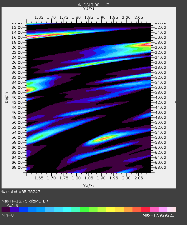
| Estimated Moho Depth: |
15.75 km |
| Estimated Crust Vp/Vs: |
1.60 |
| Assumed Crust Vp: |
5.88 km/s |
| Estimated Crust Vs: |
3.675 km/s |
| Estimated Crust Poisson's Ratio: |
0.18 |
|
| Radial Match: |
85.38247 % |
| Radial Bump: |
400 |
| Transverse Match: |
74.655975 % |
| Transverse Bump: |
400 |
| SOD ConfigId: |
3390531 |
| Insert Time: |
2019-04-14 09:54:53.689 +0000 |
| GWidth: |
2.5 |
| Max Bumps: |
400 |
| Tol: |
0.001 |
|

Signal To Noise
| Channel | StoN | STA | LTA |
| WI:DSLB:00:HHZ:20141008T02:48:37.610002Z | 7.1947255 | 2.587058E-6 | 3.59577E-7 |
| WI:DSLB:00:HHN:20141008T02:48:37.610002Z | 1.1686535 | 4.0669087E-7 | 3.4799956E-7 |
| WI:DSLB:00:HHE:20141008T02:48:37.610002Z | 7.2108083 | 2.3297866E-6 | 3.2309646E-7 |
| Arrivals |
| Ps | 1.7 SECOND |
| PpPs | 6.6 SECOND |
| PsPs/PpSs | 8.3 SECOND |


