You are here: Home > Network List > WI - West Indies IPGP Network Stations List
> Station GCMP Mount Pleasant, Carriacou, Grenada > Earthquake Result Viewer
GCMP Mount Pleasant, Carriacou, Grenada - Earthquake Result Viewer
| Earthquake location: |
Gulf Of California |
| Earthquake latitude/longitude: |
23.8/-108.4 |
| Earthquake time(UTC): |
2014/10/08 (281) 02:40:54 GMT |
| Earthquake Depth: |
10 km |
| Earthquake Magnitude: |
6.2 MWP |
| Earthquake Catalog/Contributor: |
NEIC PDE/NEIC COMCAT |
|
| Network: |
WI West Indies IPGP Network |
| Station: |
GCMP Mount Pleasant, Carriacou, Grenada |
| Lat/Lon: |
12.49 N/61.43 W |
| Elevation: |
40 m |
|
| Distance: |
45.9 deg |
| Az: |
95.655 deg |
| Baz: |
291.066 deg |
| Ray Param: |
0.07099799 |
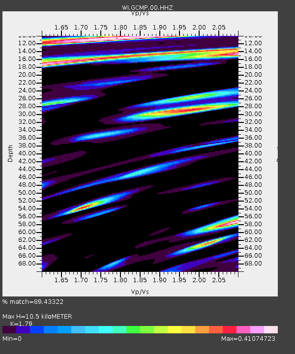
| Estimated Moho Depth: |
10.5 km |
| Estimated Crust Vp/Vs: |
1.79 |
| Assumed Crust Vp: |
5.738 km/s |
| Estimated Crust Vs: |
3.206 km/s |
| Estimated Crust Poisson's Ratio: |
0.27 |
|
| Radial Match: |
89.43322 % |
| Radial Bump: |
400 |
| Transverse Match: |
86.04382 % |
| Transverse Bump: |
400 |
| SOD ConfigId: |
3390531 |
| Insert Time: |
2019-04-14 09:54:54.261 +0000 |
| GWidth: |
2.5 |
| Max Bumps: |
400 |
| Tol: |
0.001 |
|
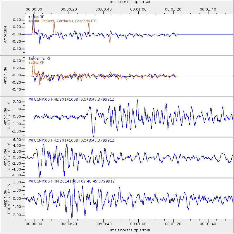
Signal To Noise
| Channel | StoN | STA | LTA |
| WI:GCMP:00:HHZ:20141008T02:48:45.379991Z | 15.855031 | 2.9929804E-6 | 1.8877165E-7 |
| WI:GCMP:00:HHN:20141008T02:48:45.379991Z | 2.1780217 | 4.4871553E-7 | 2.0601976E-7 |
| WI:GCMP:00:HHE:20141008T02:48:45.379991Z | 9.083218 | 1.3038948E-6 | 1.4354988E-7 |
| Arrivals |
| Ps | 1.5 SECOND |
| PpPs | 4.9 SECOND |
| PsPs/PpSs | 6.4 SECOND |


