You are here: Home > Network List > CN - Canadian National Seismograph Network Stations List
> Station YKW3 YKW3, NT, CANADA > Earthquake Result Viewer
YKW3 YKW3, NT, CANADA - Earthquake Result Viewer

| Earthquake location: |
Sea Of Japan |
| Earthquake latitude/longitude: |
36.8/134.9 |
| Earthquake time(UTC): |
2007/07/16 (197) 14:17:37 GMT |
| Earthquake Depth: |
350 km |
| Earthquake Magnitude: |
6.2 MB, 6.8 MW, 6.8 MW |
| Earthquake Catalog/Contributor: |
WHDF/NEIC |
|
| Network: |
CN Canadian National Seismograph Network |
| Station: |
YKW3 YKW3, NT, CANADA |
| Lat/Lon: |
62.56 N/114.61 W |
| Elevation: |
170 m |
|
| Distance: |
66.5 deg |
| Az: |
28.223 deg |
| Baz: |
304.983 deg |
| Ray Param: |
0.056434974 |
| Estimated Moho Depth: |
10.0 km |
| Estimated Crust Vp/Vs: |
1.84 |
| Assumed Crust Vp: |
6.459 km/s |
| Estimated Crust Vs: |
3.52 km/s |
| Estimated Crust Poisson's Ratio: |
0.29 |
|
| Radial Match: |
92.83236 % |
| Radial Bump: |
336 |
| Transverse Match: |
73.2004 % |
| Transverse Bump: |
400 |
| SOD ConfigId: |
2564 |
| Insert Time: |
2010-02-27 08:23:12.506 +0000 |
| GWidth: |
2.5 |
| Max Bumps: |
400 |
| Tol: |
0.001 |
|
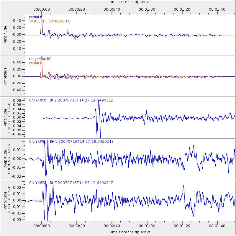
Signal To Noise
| Channel | StoN | STA | LTA |
| CN:YKW3: :BHN:20070716T14:27:19.649021Z | 14.640683 | 1.0111741E-8 | 6.906605E-10 |
| CN:YKW3: :BHE:20070716T14:27:19.649021Z | 13.291843 | 1.5389617E-8 | 1.1578242E-9 |
| CN:YKW3: :BHZ:20070716T14:27:19.649021Z | 35.8644 | 4.297081E-8 | 1.1981468E-9 |
| Arrivals |
| Ps | 1.3 SECOND |
| PpPs | 4.2 SECOND |
| PsPs/PpSs | 5.6 SECOND |


