You are here: Home > Network List > IU - Global Seismograph Network (GSN - IRIS/USGS) Stations List
> Station RSSD Black Hills, South Dakota, USA > Earthquake Result Viewer
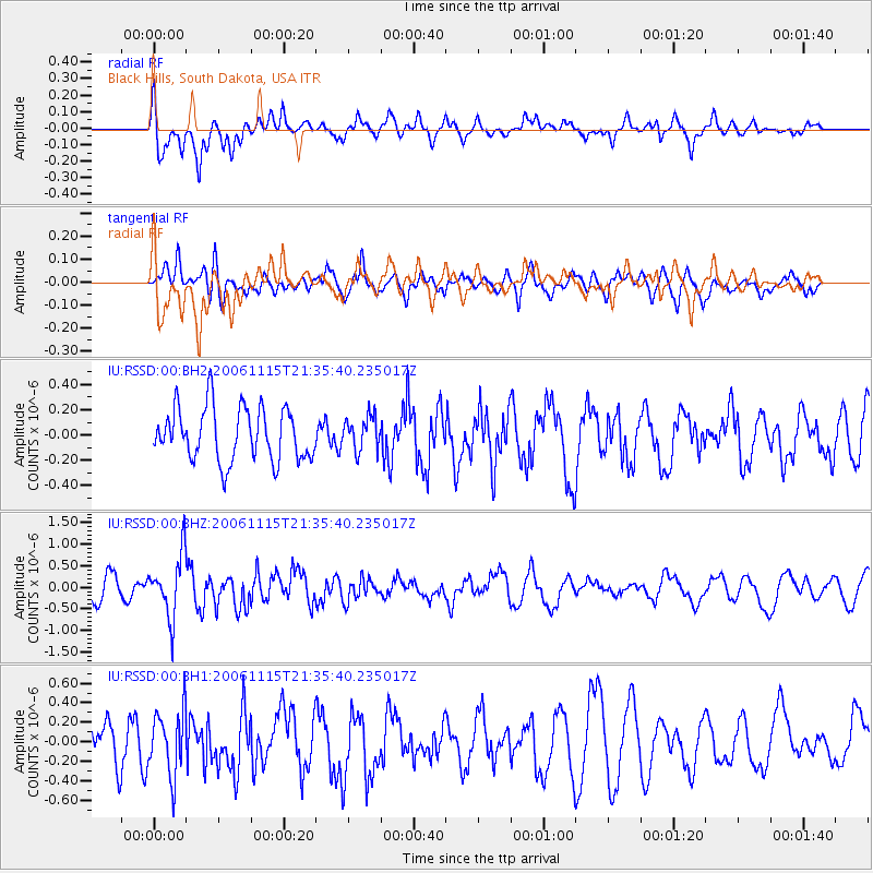
RSSD Black Hills, South Dakota, USA - Earthquake Result Viewer
*The percent match for this event was below the threshold and hence no stack was calculated.
| Earthquake location: |
Kuril Islands |
| Earthquake latitude/longitude: |
47.1/153.5 |
| Earthquake time(UTC): |
2006/11/15 (319) 21:25:22 GMT |
| Earthquake Depth: |
10 km |
| Earthquake Magnitude: |
5.7 MB |
| Earthquake Catalog/Contributor: |
WHDF/NEIC |
|
| Network: |
IU Global Seismograph Network (GSN - IRIS/USGS) |
| Station: |
RSSD Black Hills, South Dakota, USA |
| Lat/Lon: |
44.12 N/104.04 W |
| Elevation: |
2060 m |
|
| Distance: |
66.4 deg |
| Az: |
50.145 deg |
| Baz: |
313.312 deg |
| Ray Param: |
$rayparam |
*The percent match for this event was below the threshold and hence was not used in the summary stack. |
|
| Radial Match: |
56.429855 % |
| Radial Bump: |
398 |
| Transverse Match: |
45.48605 % |
| Transverse Bump: |
400 |
| SOD ConfigId: |
590571 |
| Insert Time: |
2013-09-26 03:28:21.870 +0000 |
| GWidth: |
2.5 |
| Max Bumps: |
400 |
| Tol: |
0.001 |
|
Signal To Noise
| Channel | StoN | STA | LTA |
| IU:RSSD:00:BHZ:20061115T21:35:40.235017Z | 3.013503 | 7.2782194E-7 | 2.415202E-7 |
| IU:RSSD:00:BH1:20061115T21:35:40.235017Z | 1.4061698 | 3.30714E-7 | 2.3518781E-7 |
| IU:RSSD:00:BH2:20061115T21:35:40.235017Z | 0.6315831 | 1.3232994E-7 | 2.0952103E-7 |
| Arrivals |
| Ps | |
| PpPs | |
| PsPs/PpSs | |


