You are here: Home > Network List > IU - Global Seismograph Network (GSN - IRIS/USGS) Stations List
> Station RSSD Black Hills, South Dakota, USA > Earthquake Result Viewer
RSSD Black Hills, South Dakota, USA - Earthquake Result Viewer
*The percent match for this event was below the threshold and hence no stack was calculated.
| Earthquake location: |
East Of Kuril Islands |
| Earthquake latitude/longitude: |
47.0/155.5 |
| Earthquake time(UTC): |
2006/11/17 (321) 06:33:49 GMT |
| Earthquake Depth: |
10 km |
| Earthquake Magnitude: |
5.4 MB, 5.0 MS, 5.6 MW, 5.5 MW |
| Earthquake Catalog/Contributor: |
WHDF/NEIC |
|
| Network: |
IU Global Seismograph Network (GSN - IRIS/USGS) |
| Station: |
RSSD Black Hills, South Dakota, USA |
| Lat/Lon: |
44.12 N/104.04 W |
| Elevation: |
2060 m |
|
| Distance: |
65.4 deg |
| Az: |
51.182 deg |
| Baz: |
312.25 deg |
| Ray Param: |
$rayparam |
*The percent match for this event was below the threshold and hence was not used in the summary stack. |
|
| Radial Match: |
64.37383 % |
| Radial Bump: |
400 |
| Transverse Match: |
40.533695 % |
| Transverse Bump: |
323 |
| SOD ConfigId: |
590571 |
| Insert Time: |
2013-09-26 03:39:18.500 +0000 |
| GWidth: |
2.5 |
| Max Bumps: |
400 |
| Tol: |
0.001 |
|
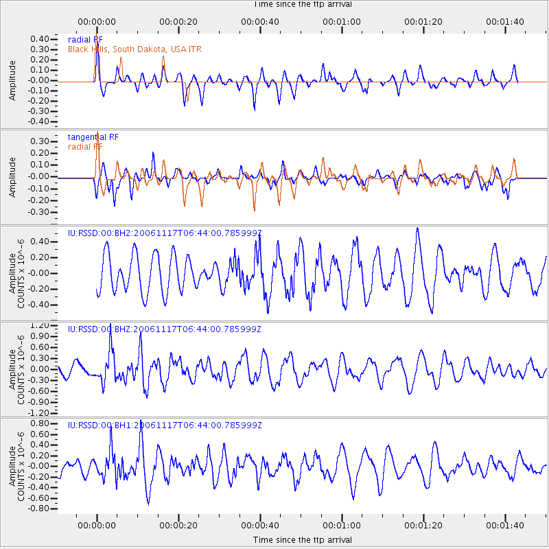
Signal To Noise
| Channel | StoN | STA | LTA |
| IU:RSSD:00:BHZ:20061117T06:44:00.785999Z | 2.8043754 | 4.3375533E-7 | 1.5467091E-7 |
| IU:RSSD:00:BH1:20061117T06:44:00.785999Z | 2.095862 | 2.6081955E-7 | 1.2444501E-7 |
| IU:RSSD:00:BH2:20061117T06:44:00.785999Z | 0.7017772 | 1.6296802E-7 | 2.3222186E-7 |
| Arrivals |
| Ps | |
| PpPs | |
| PsPs/PpSs | |


