You are here: Home > Network List > IU - Global Seismograph Network (GSN - IRIS/USGS) Stations List
> Station RSSD Black Hills, South Dakota, USA > Earthquake Result Viewer
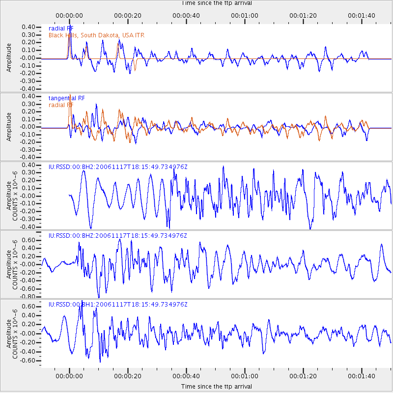
RSSD Black Hills, South Dakota, USA - Earthquake Result Viewer
*The percent match for this event was below the threshold and hence no stack was calculated.
| Earthquake location: |
Ryukyu Islands, Japan |
| Earthquake latitude/longitude: |
28.6/129.9 |
| Earthquake time(UTC): |
2006/11/17 (321) 18:03:12 GMT |
| Earthquake Depth: |
22 km |
| Earthquake Magnitude: |
5.8 MB, 5.8 MS, 6.2 MW, 6.1 MW |
| Earthquake Catalog/Contributor: |
WHDF/NEIC |
|
| Network: |
IU Global Seismograph Network (GSN - IRIS/USGS) |
| Station: |
RSSD Black Hills, South Dakota, USA |
| Lat/Lon: |
44.12 N/104.04 W |
| Elevation: |
2060 m |
|
| Distance: |
92.4 deg |
| Az: |
35.639 deg |
| Baz: |
314.645 deg |
| Ray Param: |
$rayparam |
*The percent match for this event was below the threshold and hence was not used in the summary stack. |
|
| Radial Match: |
62.480526 % |
| Radial Bump: |
400 |
| Transverse Match: |
49.17846 % |
| Transverse Bump: |
400 |
| SOD ConfigId: |
590571 |
| Insert Time: |
2013-09-26 03:40:47.778 +0000 |
| GWidth: |
2.5 |
| Max Bumps: |
400 |
| Tol: |
0.001 |
|
Signal To Noise
| Channel | StoN | STA | LTA |
| IU:RSSD:00:BHZ:20061117T18:15:49.734976Z | 1.807389 | 2.1165724E-7 | 1.1710662E-7 |
| IU:RSSD:00:BH1:20061117T18:15:49.734976Z | 3.2363687 | 3.515486E-7 | 1.08624405E-7 |
| IU:RSSD:00:BH2:20061117T18:15:49.734976Z | 1.2797292 | 2.0629427E-7 | 1.6120151E-7 |
| Arrivals |
| Ps | |
| PpPs | |
| PsPs/PpSs | |


