You are here: Home > Network List > IU - Global Seismograph Network (GSN - IRIS/USGS) Stations List
> Station RSSD Black Hills, South Dakota, USA > Earthquake Result Viewer
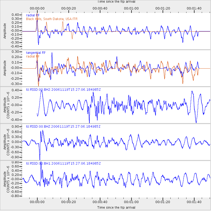
RSSD Black Hills, South Dakota, USA - Earthquake Result Viewer
*The percent match for this event was below the threshold and hence no stack was calculated.
| Earthquake location: |
East Of Kuril Islands |
| Earthquake latitude/longitude: |
46.9/154.9 |
| Earthquake time(UTC): |
2006/11/19 (323) 15:16:52 GMT |
| Earthquake Depth: |
10 km |
| Earthquake Magnitude: |
5.6 MB, 4.9 MS, 5.5 MW, 5.3 MW |
| Earthquake Catalog/Contributor: |
WHDF/NEIC |
|
| Network: |
IU Global Seismograph Network (GSN - IRIS/USGS) |
| Station: |
RSSD Black Hills, South Dakota, USA |
| Lat/Lon: |
44.12 N/104.04 W |
| Elevation: |
2060 m |
|
| Distance: |
65.8 deg |
| Az: |
50.803 deg |
| Baz: |
312.452 deg |
| Ray Param: |
$rayparam |
*The percent match for this event was below the threshold and hence was not used in the summary stack. |
|
| Radial Match: |
75.289375 % |
| Radial Bump: |
400 |
| Transverse Match: |
48.73071 % |
| Transverse Bump: |
400 |
| SOD ConfigId: |
590571 |
| Insert Time: |
2013-09-26 03:47:46.361 +0000 |
| GWidth: |
2.5 |
| Max Bumps: |
400 |
| Tol: |
0.001 |
|
Signal To Noise
| Channel | StoN | STA | LTA |
| IU:RSSD:00:BHZ:20061119T15:27:06.184985Z | 2.1293457 | 3.9354845E-7 | 1.848213E-7 |
| IU:RSSD:00:BH1:20061119T15:27:06.184985Z | 2.7351696 | 2.9857117E-7 | 1.0916002E-7 |
| IU:RSSD:00:BH2:20061119T15:27:06.184985Z | 1.115957 | 1.6105852E-7 | 1.4432324E-7 |
| Arrivals |
| Ps | |
| PpPs | |
| PsPs/PpSs | |


