You are here: Home > Network List > TA - USArray Transportable Network (new EarthScope stations) Stations List
> Station R11A Troy Canyon, Currant, NV, USA > Earthquake Result Viewer
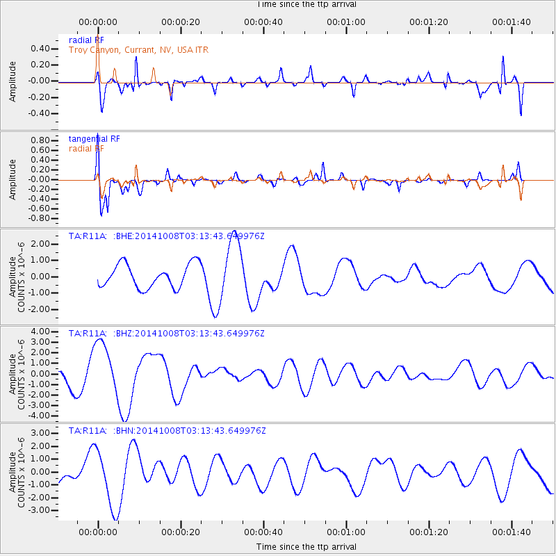
R11A Troy Canyon, Currant, NV, USA - Earthquake Result Viewer
*The percent match for this event was below the threshold and hence no stack was calculated.
| Earthquake location: |
Northern Mid-Atlantic Ridge |
| Earthquake latitude/longitude: |
30.3/-41.9 |
| Earthquake time(UTC): |
2014/10/08 (281) 03:04:07 GMT |
| Earthquake Depth: |
2.8 km |
| Earthquake Magnitude: |
5.5 MW |
| Earthquake Catalog/Contributor: |
ISC/ISC |
|
| Network: |
TA USArray Transportable Network (new EarthScope stations) |
| Station: |
R11A Troy Canyon, Currant, NV, USA |
| Lat/Lon: |
38.35 N/115.59 W |
| Elevation: |
1756 m |
|
| Distance: |
59.9 deg |
| Az: |
299.3 deg |
| Baz: |
73.589 deg |
| Ray Param: |
$rayparam |
*The percent match for this event was below the threshold and hence was not used in the summary stack. |
|
| Radial Match: |
80.68198 % |
| Radial Bump: |
390 |
| Transverse Match: |
78.77572 % |
| Transverse Bump: |
400 |
| SOD ConfigId: |
3390531 |
| Insert Time: |
2019-04-14 10:01:09.219 +0000 |
| GWidth: |
2.5 |
| Max Bumps: |
400 |
| Tol: |
0.001 |
|
Signal To Noise
| Channel | StoN | STA | LTA |
| TA:R11A: :BHZ:20141008T03:13:43.649976Z | 3.824378 | 2.5780002E-6 | 6.740966E-7 |
| TA:R11A: :BHN:20141008T03:13:43.649976Z | 2.8022332 | 2.3208843E-6 | 8.282267E-7 |
| TA:R11A: :BHE:20141008T03:13:43.649976Z | 2.7374418 | 1.9438714E-6 | 7.1010516E-7 |
| Arrivals |
| Ps | |
| PpPs | |
| PsPs/PpSs | |


