You are here: Home > Network List > CN - Canadian National Seismograph Network Stations List
> Station YKW3 YKW3, NT, CANADA > Earthquake Result Viewer
YKW3 YKW3, NT, CANADA - Earthquake Result Viewer

| Earthquake location: |
Southwestern Ryukyu Isl., Japan |
| Earthquake latitude/longitude: |
23.5/123.5 |
| Earthquake time(UTC): |
2009/08/17 (229) 00:05:49 GMT |
| Earthquake Depth: |
20 km |
| Earthquake Magnitude: |
6.2 MB, 6.6 MS, 6.7 MW, 6.6 MW |
| Earthquake Catalog/Contributor: |
WHDF/NEIC |
|
| Network: |
CN Canadian National Seismograph Network |
| Station: |
YKW3 YKW3, NT, CANADA |
| Lat/Lon: |
62.56 N/114.61 W |
| Elevation: |
170 m |
|
| Distance: |
82.7 deg |
| Az: |
23.36 deg |
| Baz: |
308.206 deg |
| Ray Param: |
0.046674546 |
| Estimated Moho Depth: |
35.0 km |
| Estimated Crust Vp/Vs: |
1.77 |
| Assumed Crust Vp: |
6.459 km/s |
| Estimated Crust Vs: |
3.655 km/s |
| Estimated Crust Poisson's Ratio: |
0.26 |
|
| Radial Match: |
96.99544 % |
| Radial Bump: |
355 |
| Transverse Match: |
88.9748 % |
| Transverse Bump: |
400 |
| SOD ConfigId: |
2622 |
| Insert Time: |
2010-02-27 08:24:08.763 +0000 |
| GWidth: |
2.5 |
| Max Bumps: |
400 |
| Tol: |
0.001 |
|
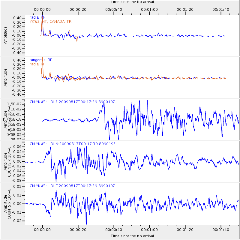
Signal To Noise
| Channel | StoN | STA | LTA |
| CN:YKW3: :BHN:20090817T00:17:39.899019Z | 40.09959 | 2.991153E-8 | 7.4593104E-10 |
| CN:YKW3: :BHE:20090817T00:17:39.899019Z | 9.619713 | 7.259145E-9 | 7.546114E-10 |
| CN:YKW3: :BHZ:20090817T00:17:39.899019Z | 10.505653 | 8.638359E-9 | 8.2225815E-10 |
| Arrivals |
| Ps | 4.3 SECOND |
| PpPs | 15 SECOND |
| PsPs/PpSs | 19 SECOND |


