You are here: Home > Network List > IU - Global Seismograph Network (GSN - IRIS/USGS) Stations List
> Station RSSD Black Hills, South Dakota, USA > Earthquake Result Viewer
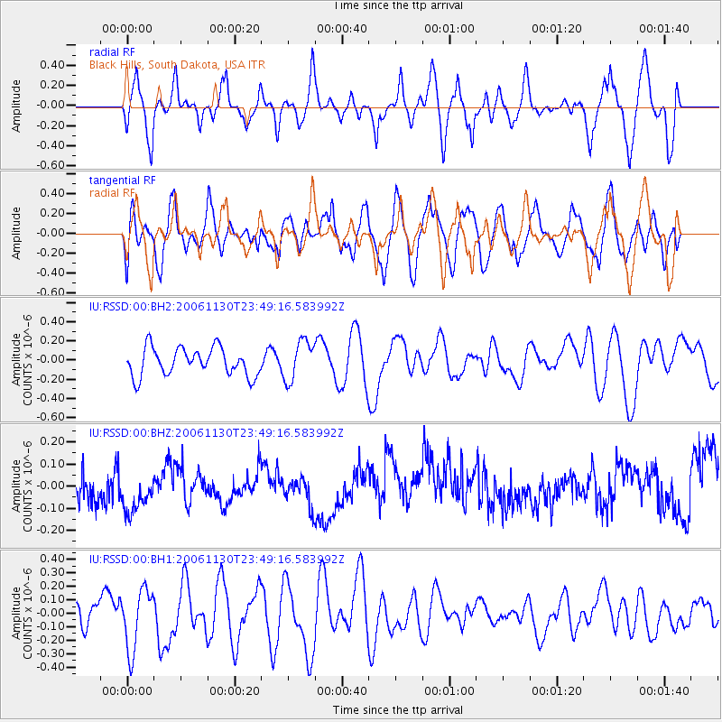
RSSD Black Hills, South Dakota, USA - Earthquake Result Viewer
*The percent match for this event was below the threshold and hence no stack was calculated.
| Earthquake location: |
Easter Island Region |
| Earthquake latitude/longitude: |
-29.8/-112.0 |
| Earthquake time(UTC): |
2006/11/30 (334) 23:38:12 GMT |
| Earthquake Depth: |
10 km |
| Earthquake Magnitude: |
5.6 MW, 5.2 MS, 5.1 MB |
| Earthquake Catalog/Contributor: |
WHDF/NEIC |
|
| Network: |
IU Global Seismograph Network (GSN - IRIS/USGS) |
| Station: |
RSSD Black Hills, South Dakota, USA |
| Lat/Lon: |
44.12 N/104.04 W |
| Elevation: |
2060 m |
|
| Distance: |
73.9 deg |
| Az: |
5.931 deg |
| Baz: |
187.166 deg |
| Ray Param: |
$rayparam |
*The percent match for this event was below the threshold and hence was not used in the summary stack. |
|
| Radial Match: |
53.83316 % |
| Radial Bump: |
327 |
| Transverse Match: |
38.136696 % |
| Transverse Bump: |
400 |
| SOD ConfigId: |
590571 |
| Insert Time: |
2013-09-26 04:12:52.890 +0000 |
| GWidth: |
2.5 |
| Max Bumps: |
400 |
| Tol: |
0.001 |
|
Signal To Noise
| Channel | StoN | STA | LTA |
| IU:RSSD:00:BHZ:20061130T23:49:16.583992Z | 1.4619732 | 1.2408654E-7 | 8.487607E-8 |
| IU:RSSD:00:BH1:20061130T23:49:16.583992Z | 1.7566744 | 2.2749207E-7 | 1.2950156E-7 |
| IU:RSSD:00:BH2:20061130T23:49:16.583992Z | 1.4615645 | 2.1086642E-7 | 1.4427445E-7 |
| Arrivals |
| Ps | |
| PpPs | |
| PsPs/PpSs | |


