You are here: Home > Network List > IU - Global Seismograph Network (GSN - IRIS/USGS) Stations List
> Station CHTO Chiang Mai, Thailand > Earthquake Result Viewer
CHTO Chiang Mai, Thailand - Earthquake Result Viewer
| Earthquake location: |
East Of Kuril Islands |
| Earthquake latitude/longitude: |
46.2/154.4 |
| Earthquake time(UTC): |
2006/12/07 (341) 19:10:21 GMT |
| Earthquake Depth: |
16 km |
| Earthquake Magnitude: |
6.3 MB, 6.1 MS, 6.3 MW, 6.3 MW |
| Earthquake Catalog/Contributor: |
WHDF/NEIC |
|
| Network: |
IU Global Seismograph Network (GSN - IRIS/USGS) |
| Station: |
CHTO Chiang Mai, Thailand |
| Lat/Lon: |
18.79 N/98.98 E |
| Elevation: |
316 m |
|
| Distance: |
52.8 deg |
| Az: |
258.12 deg |
| Baz: |
45.895 deg |
| Ray Param: |
0.066485114 |
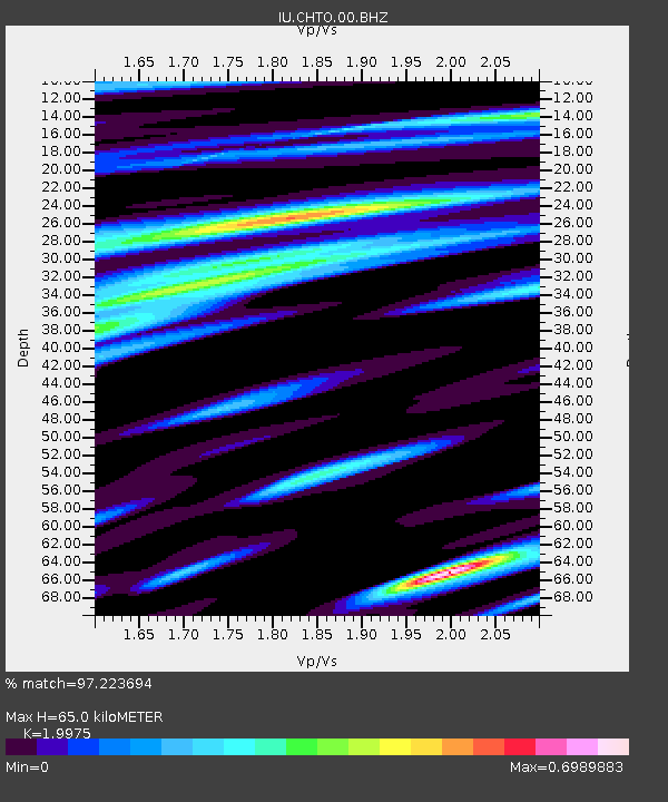
| Estimated Moho Depth: |
65.0 km |
| Estimated Crust Vp/Vs: |
2.00 |
| Assumed Crust Vp: |
6.35 km/s |
| Estimated Crust Vs: |
3.179 km/s |
| Estimated Crust Poisson's Ratio: |
0.33 |
|
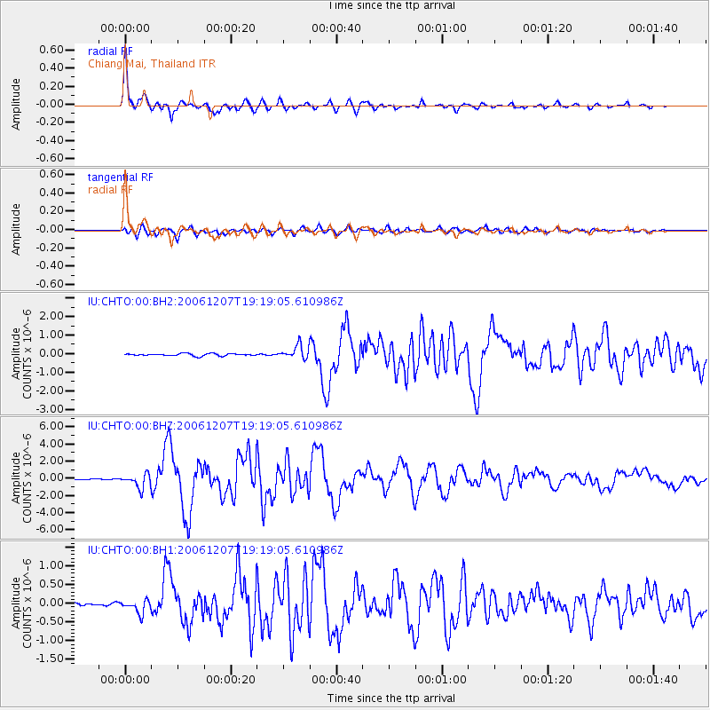
| Radial Match: |
97.223694 % |
| Radial Bump: |
359 |
| Transverse Match: |
89.043724 % |
| Transverse Bump: |
400 |
| SOD ConfigId: |
590571 |
| Insert Time: |
2013-09-26 04:26:36.950 +0000 |
| GWidth: |
2.5 |
| Max Bumps: |
400 |
| Tol: |
0.001 |
|
Signal To Noise
| Channel | StoN | STA | LTA |
| IU:CHTO:00:BHZ:20061207T19:19:05.610986Z | 14.470679 | 8.2993745E-7 | 5.735304E-8 |
| IU:CHTO:00:BH1:20061207T19:19:05.610986Z | 4.64977 | 1.8104386E-7 | 3.8936093E-8 |
| IU:CHTO:00:BH2:20061207T19:19:05.610986Z | 5.9663906 | 3.5427E-7 | 5.9377605E-8 |
| Arrivals |
| Ps | 11 SECOND |
| PpPs | 29 SECOND |
| PsPs/PpSs | 40 SECOND |


