You are here: Home > Network List > CN - Canadian National Seismograph Network Stations List
> Station YKW3 YKW3, NT, CANADA > Earthquake Result Viewer
YKW3 YKW3, NT, CANADA - Earthquake Result Viewer

| Earthquake location: |
Northern Mid-Atlantic Ridge |
| Earthquake latitude/longitude: |
23.9/-46.1 |
| Earthquake time(UTC): |
2009/06/06 (157) 20:33:28 GMT |
| Earthquake Depth: |
14 km |
| Earthquake Magnitude: |
6.0 MB, 5.7 MS, 6.0 MW, 6.0 MW |
| Earthquake Catalog/Contributor: |
WHDF/NEIC |
|
| Network: |
CN Canadian National Seismograph Network |
| Station: |
YKW3 YKW3, NT, CANADA |
| Lat/Lon: |
62.56 N/114.61 W |
| Elevation: |
170 m |
|
| Distance: |
59.2 deg |
| Az: |
329.884 deg |
| Baz: |
97.42 deg |
| Ray Param: |
0.06233162 |
| Estimated Moho Depth: |
38.75 km |
| Estimated Crust Vp/Vs: |
1.80 |
| Assumed Crust Vp: |
6.459 km/s |
| Estimated Crust Vs: |
3.584 km/s |
| Estimated Crust Poisson's Ratio: |
0.28 |
|
| Radial Match: |
92.90022 % |
| Radial Bump: |
318 |
| Transverse Match: |
77.83828 % |
| Transverse Bump: |
400 |
| SOD ConfigId: |
2648 |
| Insert Time: |
2010-02-27 08:25:09.440 +0000 |
| GWidth: |
2.5 |
| Max Bumps: |
400 |
| Tol: |
0.001 |
|
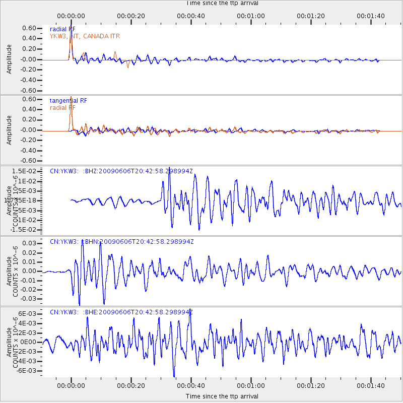
Signal To Noise
| Channel | StoN | STA | LTA |
| CN:YKW3: :BHN:20090606T20:42:58.298994Z | 11.540835 | 1.7793772E-8 | 1.5418097E-9 |
| CN:YKW3: :BHE:20090606T20:42:58.298994Z | 1.1142493 | 1.1036236E-9 | 9.904637E-10 |
| CN:YKW3: :BHZ:20090606T20:42:58.298994Z | 6.042515 | 7.493154E-9 | 1.240072E-9 |
| Arrivals |
| Ps | 5.0 SECOND |
| PpPs | 16 SECOND |
| PsPs/PpSs | 21 SECOND |


