You are here: Home > Network List > XJ13 - CRAFTI Stations List
> Station PR33 Engutoto Boma > Earthquake Result Viewer
PR33 Engutoto Boma - Earthquake Result Viewer
| Earthquake location: |
North Of Svalbard |
| Earthquake latitude/longitude: |
80.6/-2.6 |
| Earthquake time(UTC): |
2014/10/08 (281) 10:29:57 GMT |
| Earthquake Depth: |
8.2 km |
| Earthquake Magnitude: |
5.0 MW |
| Earthquake Catalog/Contributor: |
ISC/ISC |
|
| Network: |
XJ CRAFTI |
| Station: |
PR33 Engutoto Boma |
| Lat/Lon: |
2.84 S/36.14 E |
| Elevation: |
1101 m |
|
| Distance: |
85.5 deg |
| Az: |
141.175 deg |
| Baz: |
354.099 deg |
| Ray Param: |
0.044748526 |
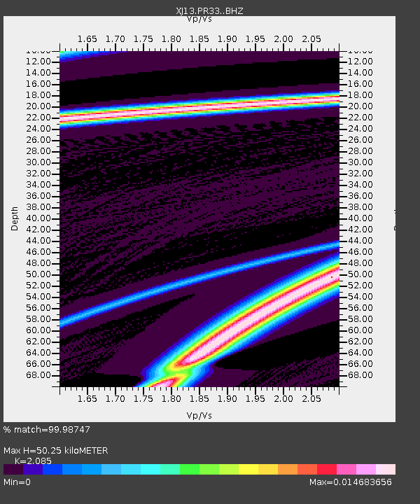
| Estimated Moho Depth: |
50.25 km |
| Estimated Crust Vp/Vs: |
2.09 |
| Assumed Crust Vp: |
6.601 km/s |
| Estimated Crust Vs: |
3.166 km/s |
| Estimated Crust Poisson's Ratio: |
0.35 |
|
| Radial Match: |
99.98747 % |
| Radial Bump: |
3 |
| Transverse Match: |
99.98146 % |
| Transverse Bump: |
5 |
| SOD ConfigId: |
3390531 |
| Insert Time: |
2019-04-14 10:15:05.541 +0000 |
| GWidth: |
2.5 |
| Max Bumps: |
400 |
| Tol: |
0.001 |
|

Signal To Noise
| Channel | StoN | STA | LTA |
| XJ:PR33: :BHZ:20141008T10:42:04.039995Z | 8.692431 | 3.5371733E-4 | 4.069257E-5 |
| XJ:PR33: :BHN:20141008T10:42:04.039995Z | 8.412131 | 8.279834E-4 | 9.84273E-5 |
| XJ:PR33: :BHE:20141008T10:42:04.039995Z | 8.280011 | 2.729939E-4 | 3.2970238E-5 |
| Arrivals |
| Ps | 8.4 SECOND |
| PpPs | 23 SECOND |
| PsPs/PpSs | 31 SECOND |


