You are here: Home > Network List > GS - US Geological Survey Networks Stations List
> Station DEC07 Harrison Ave Surface Site > Earthquake Result Viewer
DEC07 Harrison Ave Surface Site - Earthquake Result Viewer
| Earthquake location: |
Southern East Pacific Rise |
| Earthquake latitude/longitude: |
-32.1/-110.8 |
| Earthquake time(UTC): |
2014/10/09 (282) 02:14:32 GMT |
| Earthquake Depth: |
16 km |
| Earthquake Magnitude: |
7.1 MWW, 6.8 MI |
| Earthquake Catalog/Contributor: |
NEIC PDE/NEIC COMCAT |
|
| Network: |
GS US Geological Survey Networks |
| Station: |
DEC07 Harrison Ave Surface Site |
| Lat/Lon: |
39.86 N/88.90 W |
| Elevation: |
212 m |
|
| Distance: |
74.4 deg |
| Az: |
17.322 deg |
| Baz: |
199.164 deg |
| Ray Param: |
0.05232414 |
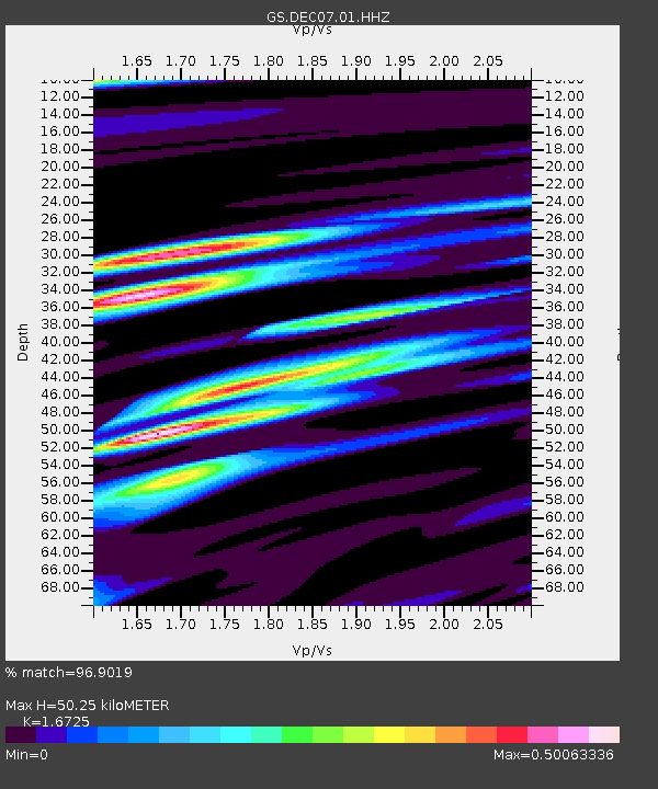
| Estimated Moho Depth: |
50.25 km |
| Estimated Crust Vp/Vs: |
1.67 |
| Assumed Crust Vp: |
6.444 km/s |
| Estimated Crust Vs: |
3.853 km/s |
| Estimated Crust Poisson's Ratio: |
0.22 |
|
| Radial Match: |
96.9019 % |
| Radial Bump: |
321 |
| Transverse Match: |
91.78187 % |
| Transverse Bump: |
400 |
| SOD ConfigId: |
3390531 |
| Insert Time: |
2019-04-14 10:19:38.294 +0000 |
| GWidth: |
2.5 |
| Max Bumps: |
400 |
| Tol: |
0.001 |
|
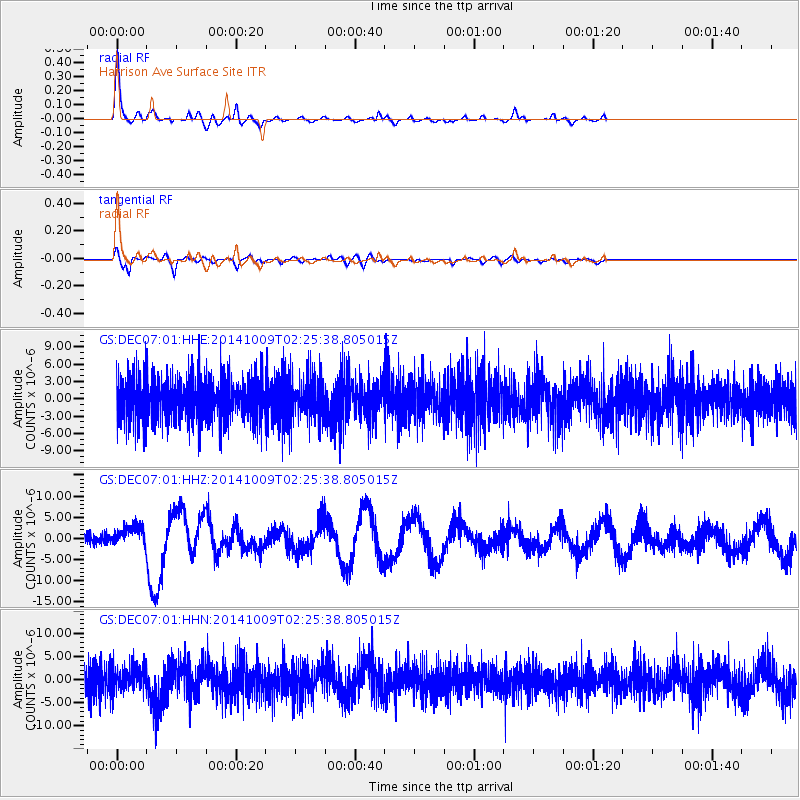
Signal To Noise
| Channel | StoN | STA | LTA |
| GS:DEC07:01:HHZ:20141009T02:25:38.805015Z | 2.2654338 | 2.3436457E-6 | 1.0345241E-6 |
| GS:DEC07:01:HHN:20141009T02:25:38.805015Z | 1.01042 | 2.6703738E-6 | 2.6428356E-6 |
| GS:DEC07:01:HHE:20141009T02:25:38.805015Z | 0.96177197 | 3.786958E-6 | 3.93748E-6 |
| Arrivals |
| Ps | 5.4 SECOND |
| PpPs | 20 SECOND |
| PsPs/PpSs | 26 SECOND |


