You are here: Home > Network List > NM - Cooperative New Madrid Seismic Network Stations List
> Station SIUC Carbondale, IL > Earthquake Result Viewer
SIUC Carbondale, IL - Earthquake Result Viewer
| Earthquake location: |
Southern East Pacific Rise |
| Earthquake latitude/longitude: |
-32.1/-110.8 |
| Earthquake time(UTC): |
2014/10/09 (282) 02:14:32 GMT |
| Earthquake Depth: |
16 km |
| Earthquake Magnitude: |
7.1 MWW, 6.8 MI |
| Earthquake Catalog/Contributor: |
NEIC PDE/NEIC COMCAT |
|
| Network: |
NM Cooperative New Madrid Seismic Network |
| Station: |
SIUC Carbondale, IL |
| Lat/Lon: |
37.71 N/89.22 W |
| Elevation: |
120 m |
|
| Distance: |
72.3 deg |
| Az: |
17.811 deg |
| Baz: |
199.105 deg |
| Ray Param: |
0.05372372 |
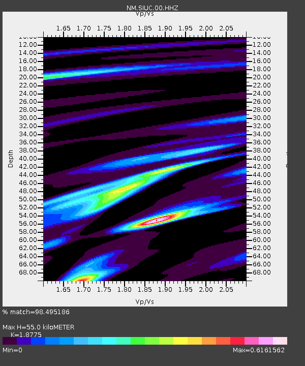
| Estimated Moho Depth: |
55.0 km |
| Estimated Crust Vp/Vs: |
1.88 |
| Assumed Crust Vp: |
6.444 km/s |
| Estimated Crust Vs: |
3.432 km/s |
| Estimated Crust Poisson's Ratio: |
0.30 |
|
| Radial Match: |
98.495186 % |
| Radial Bump: |
259 |
| Transverse Match: |
86.84332 % |
| Transverse Bump: |
400 |
| SOD ConfigId: |
3390531 |
| Insert Time: |
2019-04-14 10:20:39.000 +0000 |
| GWidth: |
2.5 |
| Max Bumps: |
400 |
| Tol: |
0.001 |
|

Signal To Noise
| Channel | StoN | STA | LTA |
| NM:SIUC:00:HHZ:20141009T02:25:26.43801Z | 14.658452 | 2.053717E-6 | 1.4010463E-7 |
| NM:SIUC:00:HHN:20141009T02:25:26.43801Z | 8.44149 | 9.4012563E-7 | 1.1136963E-7 |
| NM:SIUC:00:HHE:20141009T02:25:26.43801Z | 4.4227915 | 3.698681E-7 | 8.3627754E-8 |
| Arrivals |
| Ps | 7.7 SECOND |
| PpPs | 24 SECOND |
| PsPs/PpSs | 32 SECOND |


