You are here: Home > Network List > NX - Nanometrics Research Network Stations List
> Station STN31 Seismic station 26 > Earthquake Result Viewer
STN31 Seismic station 26 - Earthquake Result Viewer
| Earthquake location: |
Southern East Pacific Rise |
| Earthquake latitude/longitude: |
-32.1/-110.8 |
| Earthquake time(UTC): |
2014/10/09 (282) 02:14:32 GMT |
| Earthquake Depth: |
16 km |
| Earthquake Magnitude: |
7.1 MWW, 6.8 MI |
| Earthquake Catalog/Contributor: |
NEIC PDE/NEIC COMCAT |
|
| Network: |
NX Nanometrics Research Network |
| Station: |
STN31 Seismic station 26 |
| Lat/Lon: |
35.76 N/97.44 W |
| Elevation: |
329 m |
|
| Distance: |
68.7 deg |
| Az: |
11.619 deg |
| Baz: |
192.13 deg |
| Ray Param: |
0.05614302 |
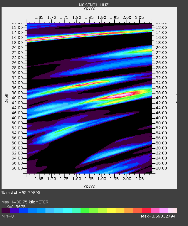
| Estimated Moho Depth: |
38.75 km |
| Estimated Crust Vp/Vs: |
1.97 |
| Assumed Crust Vp: |
6.426 km/s |
| Estimated Crust Vs: |
3.266 km/s |
| Estimated Crust Poisson's Ratio: |
0.33 |
|
| Radial Match: |
95.70805 % |
| Radial Bump: |
275 |
| Transverse Match: |
93.38512 % |
| Transverse Bump: |
319 |
| SOD ConfigId: |
3390531 |
| Insert Time: |
2019-04-14 10:21:01.755 +0000 |
| GWidth: |
2.5 |
| Max Bumps: |
400 |
| Tol: |
0.001 |
|

Signal To Noise
| Channel | StoN | STA | LTA |
| NX:STN31: :HHZ:20141009T02:25:04.159995Z | 9.902197 | 1.1997132E-6 | 1.2115626E-7 |
| NX:STN31: :HH1:20141009T02:25:04.159995Z | 2.066086 | 3.822637E-7 | 1.850183E-7 |
| NX:STN31: :HH2:20141009T02:25:04.159995Z | 1.2434467 | 2.4975645E-7 | 2.0085818E-7 |
| Arrivals |
| Ps | 6.0 SECOND |
| PpPs | 17 SECOND |
| PsPs/PpSs | 23 SECOND |


