You are here: Home > Network List > OK - Oklahoma Seismic Network Stations List
> Station LOV3 Lake Murray, OK > Earthquake Result Viewer
LOV3 Lake Murray, OK - Earthquake Result Viewer
| Earthquake location: |
Southern East Pacific Rise |
| Earthquake latitude/longitude: |
-32.1/-110.8 |
| Earthquake time(UTC): |
2014/10/09 (282) 02:14:32 GMT |
| Earthquake Depth: |
16 km |
| Earthquake Magnitude: |
7.1 MWW, 6.8 MI |
| Earthquake Catalog/Contributor: |
NEIC PDE/NEIC COMCAT |
|
| Network: |
OK Oklahoma Seismic Network |
| Station: |
LOV3 Lake Murray, OK |
| Lat/Lon: |
34.01 N/97.08 W |
| Elevation: |
205 m |
|
| Distance: |
67.0 deg |
| Az: |
12.332 deg |
| Baz: |
192.603 deg |
| Ray Param: |
0.057211403 |
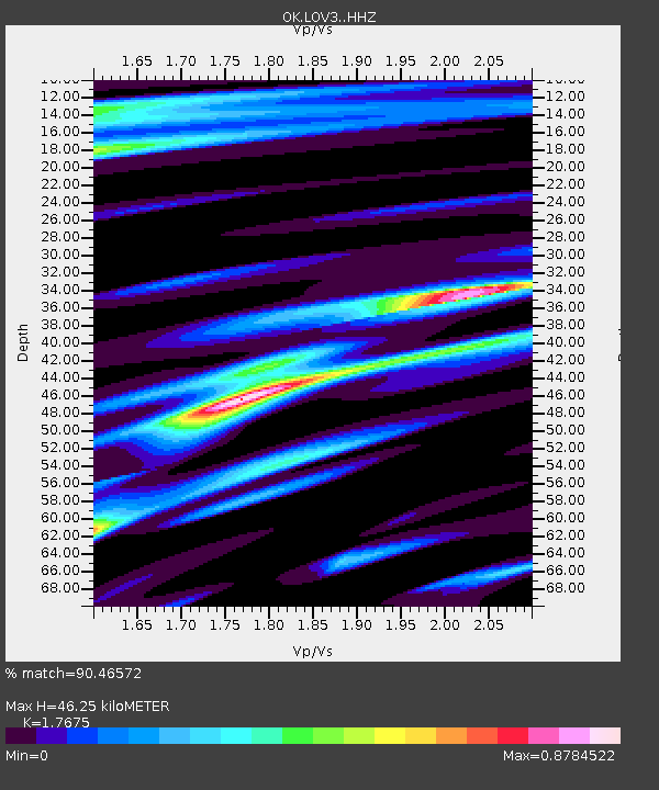
| Estimated Moho Depth: |
46.25 km |
| Estimated Crust Vp/Vs: |
1.77 |
| Assumed Crust Vp: |
6.426 km/s |
| Estimated Crust Vs: |
3.636 km/s |
| Estimated Crust Poisson's Ratio: |
0.26 |
|
| Radial Match: |
90.46572 % |
| Radial Bump: |
400 |
| Transverse Match: |
84.87806 % |
| Transverse Bump: |
400 |
| SOD ConfigId: |
3390531 |
| Insert Time: |
2019-04-14 10:21:08.097 +0000 |
| GWidth: |
2.5 |
| Max Bumps: |
400 |
| Tol: |
0.001 |
|

Signal To Noise
| Channel | StoN | STA | LTA |
| OK:LOV3: :HHZ:20141009T02:24:53.899009Z | 9.657636 | 1.9953056E-6 | 2.0660396E-7 |
| OK:LOV3: :HHN:20141009T02:24:53.899009Z | 2.6112905 | 6.758044E-7 | 2.5880092E-7 |
| OK:LOV3: :HHE:20141009T02:24:53.899009Z | 1.0701647 | 2.7077473E-7 | 2.5302154E-7 |
| Arrivals |
| Ps | 5.7 SECOND |
| PpPs | 19 SECOND |
| PsPs/PpSs | 25 SECOND |


