You are here: Home > Network List > IU - Global Seismograph Network (GSN - IRIS/USGS) Stations List
> Station RSSD Black Hills, South Dakota, USA > Earthquake Result Viewer
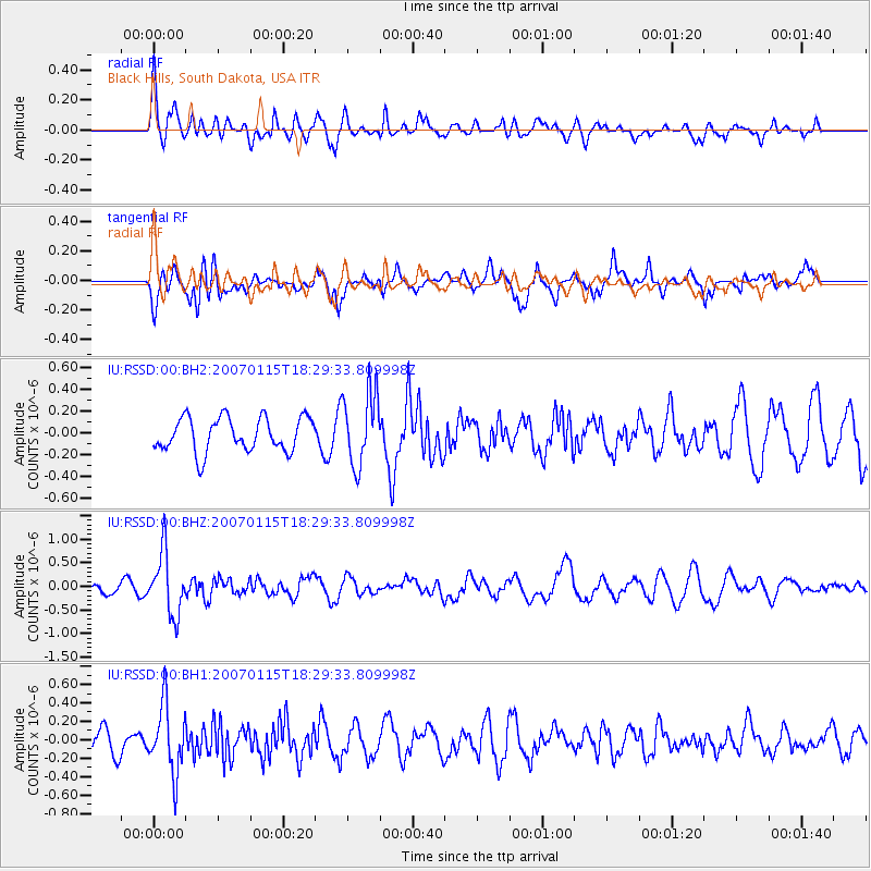
RSSD Black Hills, South Dakota, USA - Earthquake Result Viewer
*The percent match for this event was below the threshold and hence no stack was calculated.
| Earthquake location: |
Near S. Coast Of Honshu, Japan |
| Earthquake latitude/longitude: |
34.9/138.6 |
| Earthquake time(UTC): |
2007/01/15 (015) 18:17:59 GMT |
| Earthquake Depth: |
170 km |
| Earthquake Magnitude: |
5.7 MB, 5.9 MW, 5.9 MW |
| Earthquake Catalog/Contributor: |
WHDF/NEIC |
|
| Network: |
IU Global Seismograph Network (GSN - IRIS/USGS) |
| Station: |
RSSD Black Hills, South Dakota, USA |
| Lat/Lon: |
44.12 N/104.04 W |
| Elevation: |
2060 m |
|
| Distance: |
82.9 deg |
| Az: |
40.149 deg |
| Baz: |
312.614 deg |
| Ray Param: |
$rayparam |
*The percent match for this event was below the threshold and hence was not used in the summary stack. |
|
| Radial Match: |
57.27392 % |
| Radial Bump: |
400 |
| Transverse Match: |
66.00575 % |
| Transverse Bump: |
400 |
| SOD ConfigId: |
590571 |
| Insert Time: |
2013-09-26 05:30:54.210 +0000 |
| GWidth: |
2.5 |
| Max Bumps: |
400 |
| Tol: |
0.001 |
|
Signal To Noise
| Channel | StoN | STA | LTA |
| IU:RSSD:00:BHZ:20070115T18:29:33.809998Z | 8.216775 | 6.527363E-7 | 7.9439474E-8 |
| IU:RSSD:00:BH1:20070115T18:29:33.809998Z | 2.557386 | 3.670954E-7 | 1.4354322E-7 |
| IU:RSSD:00:BH2:20070115T18:29:33.809998Z | 2.185082 | 3.3874872E-7 | 1.5502793E-7 |
| Arrivals |
| Ps | |
| PpPs | |
| PsPs/PpSs | |


