You are here: Home > Network List > PR - Puerto Rico Seismic Network (PRSN) & Puerto Rico Strong Motion Program (PRSMP) Stations List
> Station MLPR Magueyes > Earthquake Result Viewer
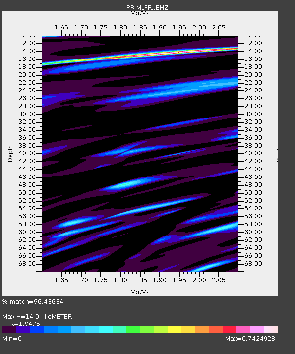
MLPR Magueyes - Earthquake Result Viewer
| Earthquake location: |
Southern East Pacific Rise |
| Earthquake latitude/longitude: |
-32.1/-110.8 |
| Earthquake time(UTC): |
2014/10/09 (282) 02:14:32 GMT |
| Earthquake Depth: |
16 km |
| Earthquake Magnitude: |
7.1 MWW, 6.8 MI |
| Earthquake Catalog/Contributor: |
NEIC PDE/NEIC COMCAT |
|
| Network: |
PR Puerto Rico Seismic Network (PRSN) & Puerto Rico Strong Motion Program (PRSMP) |
| Station: |
MLPR Magueyes |
| Lat/Lon: |
17.97 N/67.04 W |
| Elevation: |
0.0 m |
|
| Distance: |
65.1 deg |
| Az: |
46.517 deg |
| Baz: |
220.307 deg |
| Ray Param: |
0.05849628 |
| Estimated Moho Depth: |
14.0 km |
| Estimated Crust Vp/Vs: |
1.95 |
| Assumed Crust Vp: |
4.082 km/s |
| Estimated Crust Vs: |
2.096 km/s |
| Estimated Crust Poisson's Ratio: |
0.32 |
|
| Radial Match: |
96.43634 % |
| Radial Bump: |
400 |
| Transverse Match: |
91.00015 % |
| Transverse Bump: |
400 |
| SOD ConfigId: |
3390531 |
| Insert Time: |
2019-04-14 10:21:38.112 +0000 |
| GWidth: |
2.5 |
| Max Bumps: |
400 |
| Tol: |
0.001 |
|

Signal To Noise
| Channel | StoN | STA | LTA |
| PR:MLPR: :BHZ:20141009T02:24:41.480002Z | 13.002379 | 2.2613317E-6 | 1.7391676E-7 |
| PR:MLPR: :BHN:20141009T02:24:41.480002Z | 4.4442625 | 7.3707736E-7 | 1.6584919E-7 |
| PR:MLPR: :BHE:20141009T02:24:41.480002Z | 5.6736436 | 7.923056E-7 | 1.396467E-7 |
| Arrivals |
| Ps | 3.3 SECOND |
| PpPs | 10.0 SECOND |
| PsPs/PpSs | 13 SECOND |


