You are here: Home > Network List > TO - Tectonic Observatory Stations List
> Station CC31 CCSE CC31 > Earthquake Result Viewer
CC31 CCSE CC31 - Earthquake Result Viewer
| Earthquake location: |
Southern East Pacific Rise |
| Earthquake latitude/longitude: |
-32.1/-110.8 |
| Earthquake time(UTC): |
2014/10/09 (282) 02:14:32 GMT |
| Earthquake Depth: |
16 km |
| Earthquake Magnitude: |
7.1 MWW, 6.8 MI |
| Earthquake Catalog/Contributor: |
NEIC PDE/NEIC COMCAT |
|
| Network: |
TO Tectonic Observatory |
| Station: |
CC31 CCSE CC31 |
| Lat/Lon: |
36.32 N/119.27 W |
| Elevation: |
93 m |
|
| Distance: |
68.5 deg |
| Az: |
352.635 deg |
| Baz: |
172.259 deg |
| Ray Param: |
0.05622572 |
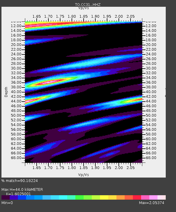
| Estimated Moho Depth: |
44.0 km |
| Estimated Crust Vp/Vs: |
1.60 |
| Assumed Crust Vp: |
6.291 km/s |
| Estimated Crust Vs: |
3.926 km/s |
| Estimated Crust Poisson's Ratio: |
0.18 |
|
| Radial Match: |
90.18224 % |
| Radial Bump: |
400 |
| Transverse Match: |
81.93641 % |
| Transverse Bump: |
400 |
| SOD ConfigId: |
3390531 |
| Insert Time: |
2019-04-14 10:22:48.898 +0000 |
| GWidth: |
2.5 |
| Max Bumps: |
400 |
| Tol: |
0.001 |
|

Signal To Noise
| Channel | StoN | STA | LTA |
| TO:CC31: :HHZ:20141009T02:25:03.139976Z | 9.976748 | 2.0391938E-6 | 2.0439462E-7 |
| TO:CC31: :HHN:20141009T02:25:03.139976Z | 2.6255345 | 1.0277921E-6 | 3.9146013E-7 |
| TO:CC31: :HHE:20141009T02:25:03.139976Z | 1.194218 | 3.9042243E-7 | 3.2692728E-7 |
| Arrivals |
| Ps | 4.4 SECOND |
| PpPs | 17 SECOND |
| PsPs/PpSs | 22 SECOND |


