You are here: Home > Network List > CI - Caltech Regional Seismic Network Stations List
> Station TIN Tinemaha, California, USA > Earthquake Result Viewer
TIN Tinemaha, California, USA - Earthquake Result Viewer
| Earthquake location: |
Near Coast Of Chiapas, Mexico |
| Earthquake latitude/longitude: |
15.0/-92.4 |
| Earthquake time(UTC): |
2000/03/12 (072) 22:21:30 GMT |
| Earthquake Depth: |
62 km |
| Earthquake Magnitude: |
5.5 MB, 5.8 MS, 6.3 MW, 5.4 MD |
| Earthquake Catalog/Contributor: |
WHDF/NEIC |
|
| Network: |
CI Caltech Regional Seismic Network |
| Station: |
TIN Tinemaha, California, USA |
| Lat/Lon: |
37.05 N/118.23 W |
| Elevation: |
1164 m |
|
| Distance: |
31.8 deg |
| Az: |
318.611 deg |
| Baz: |
126.991 deg |
| Ray Param: |
0.07879932 |
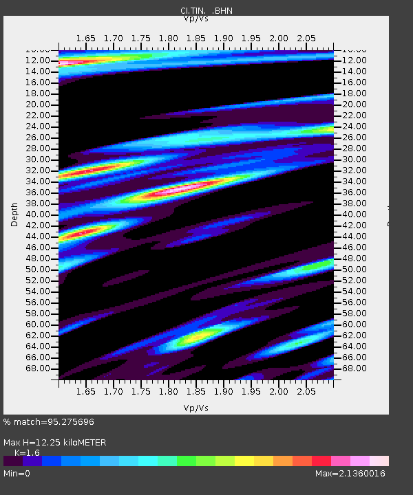
| Estimated Moho Depth: |
12.25 km |
| Estimated Crust Vp/Vs: |
1.60 |
| Assumed Crust Vp: |
6.291 km/s |
| Estimated Crust Vs: |
3.932 km/s |
| Estimated Crust Poisson's Ratio: |
0.18 |
|
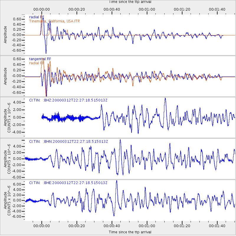
| Radial Match: |
95.275696 % |
| Radial Bump: |
400 |
| Transverse Match: |
87.59047 % |
| Transverse Bump: |
400 |
| SOD ConfigId: |
3744 |
| Insert Time: |
2010-02-25 20:45:29.671 +0000 |
| GWidth: |
2.5 |
| Max Bumps: |
400 |
| Tol: |
0.001 |
|
Signal To Noise
| Channel | StoN | STA | LTA |
| CI:TIN: :BHN:20000312T22:27:18.515013Z | 1.257446 | 5.2533045E-7 | 4.1777574E-7 |
| CI:TIN: :BHE:20000312T22:27:18.515013Z | 1.3492432 | 5.156245E-7 | 3.821583E-7 |
| CI:TIN: :BHZ:20000312T22:27:18.515013Z | 2.435047 | 1.1805383E-6 | 4.848114E-7 |
| Arrivals |
| Ps | 1.3 SECOND |
| PpPs | 4.7 SECOND |
| PsPs/PpSs | 5.9 SECOND |


