You are here: Home > Network List > X812 - Deep Structure of Three Continental Sutures in Eastern North America Stations List
> Station QMHP Harpswell, Maine > Earthquake Result Viewer
QMHP Harpswell, Maine - Earthquake Result Viewer
| Earthquake location: |
Southern East Pacific Rise |
| Earthquake latitude/longitude: |
-32.1/-110.8 |
| Earthquake time(UTC): |
2014/10/09 (282) 02:14:32 GMT |
| Earthquake Depth: |
16 km |
| Earthquake Magnitude: |
7.1 MWW, 6.8 MI |
| Earthquake Catalog/Contributor: |
NEIC PDE/NEIC COMCAT |
|
| Network: |
X8 Deep Structure of Three Continental Sutures in Eastern North America |
| Station: |
QMHP Harpswell, Maine |
| Lat/Lon: |
43.75 N/70.01 W |
| Elevation: |
22 m |
|
| Distance: |
84.2 deg |
| Az: |
28.404 deg |
| Baz: |
213.847 deg |
| Ray Param: |
0.04564877 |
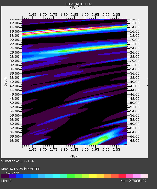
| Estimated Moho Depth: |
15.25 km |
| Estimated Crust Vp/Vs: |
1.77 |
| Assumed Crust Vp: |
6.419 km/s |
| Estimated Crust Vs: |
3.616 km/s |
| Estimated Crust Poisson's Ratio: |
0.27 |
|
| Radial Match: |
91.77154 % |
| Radial Bump: |
400 |
| Transverse Match: |
69.89708 % |
| Transverse Bump: |
400 |
| SOD ConfigId: |
3390531 |
| Insert Time: |
2019-04-14 10:23:43.200 +0000 |
| GWidth: |
2.5 |
| Max Bumps: |
400 |
| Tol: |
0.001 |
|

Signal To Noise
| Channel | StoN | STA | LTA |
| X8:QMHP: :HHZ:20141009T02:26:31.730002Z | 7.2669024 | 2.211971E-6 | 3.043898E-7 |
| X8:QMHP: :HHN:20141009T02:26:31.730002Z | 4.1703944 | 1.2365739E-6 | 2.9651247E-7 |
| X8:QMHP: :HHE:20141009T02:26:31.730002Z | 1.1715468 | 4.8550714E-7 | 4.1441552E-7 |
| Arrivals |
| Ps | 1.9 SECOND |
| PpPs | 6.4 SECOND |
| PsPs/PpSs | 8.3 SECOND |


