You are here: Home > Network List > XD14 - Illuminating the architecture of the greater Mount St. Helens magmatic systems f Stations List
> Station MC08 "Mount St Helens, WA" > Earthquake Result Viewer
MC08 "Mount St Helens, WA" - Earthquake Result Viewer
| Earthquake location: |
Southern East Pacific Rise |
| Earthquake latitude/longitude: |
-32.1/-110.8 |
| Earthquake time(UTC): |
2014/10/09 (282) 02:14:32 GMT |
| Earthquake Depth: |
16 km |
| Earthquake Magnitude: |
7.1 MWW, 6.8 MI |
| Earthquake Catalog/Contributor: |
NEIC PDE/NEIC COMCAT |
|
| Network: |
XD Illuminating the architecture of the greater Mount St. Helens magmatic systems f |
| Station: |
MC08 "Mount St Helens, WA" |
| Lat/Lon: |
46.55 N/121.96 W |
| Elevation: |
653 m |
|
| Distance: |
79.0 deg |
| Az: |
352.161 deg |
| Baz: |
170.346 deg |
| Ray Param: |
0.049282596 |
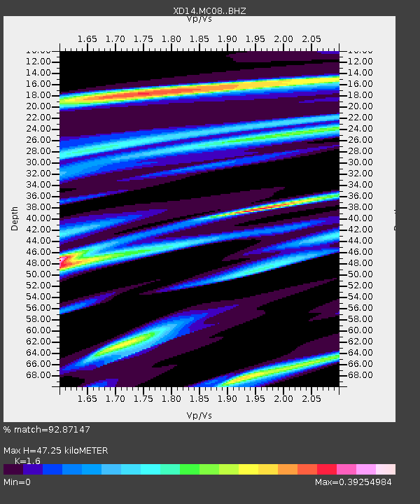
| Estimated Moho Depth: |
47.25 km |
| Estimated Crust Vp/Vs: |
1.60 |
| Assumed Crust Vp: |
6.597 km/s |
| Estimated Crust Vs: |
4.123 km/s |
| Estimated Crust Poisson's Ratio: |
0.18 |
|
| Radial Match: |
92.87147 % |
| Radial Bump: |
362 |
| Transverse Match: |
84.096924 % |
| Transverse Bump: |
400 |
| SOD ConfigId: |
3390531 |
| Insert Time: |
2019-04-14 10:23:47.903 +0000 |
| GWidth: |
2.5 |
| Max Bumps: |
400 |
| Tol: |
0.001 |
|

Signal To Noise
| Channel | StoN | STA | LTA |
| XD:MC08: :BHZ:20141009T02:26:03.940024Z | 18.383465 | 2.4804594E-6 | 1.3492884E-7 |
| XD:MC08: :BHN:20141009T02:26:03.940024Z | 5.7017107 | 7.56047E-7 | 1.3260004E-7 |
| XD:MC08: :BHE:20141009T02:26:03.940024Z | 0.59718585 | 1.4901713E-7 | 2.4953223E-7 |
| Arrivals |
| Ps | 4.4 SECOND |
| PpPs | 18 SECOND |
| PsPs/PpSs | 22 SECOND |


