You are here: Home > Network List > YS04 - Plume Lithosphere Undersea Melt Experiment Stations List
> Station PL71 WHOI OBS ID S30 > Earthquake Result Viewer
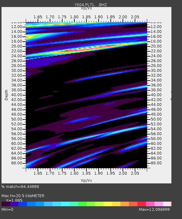
PL71 WHOI OBS ID S30 - Earthquake Result Viewer
| Earthquake location: |
Vanuatu Islands |
| Earthquake latitude/longitude: |
-13.1/167.1 |
| Earthquake time(UTC): |
2007/01/23 (023) 17:16:20 GMT |
| Earthquake Depth: |
188 km |
| Earthquake Magnitude: |
5.9 MB, 5.9 MW, 5.8 MW |
| Earthquake Catalog/Contributor: |
WHDF/NEIC |
|
| Network: |
YS Plume Lithosphere Undersea Melt Experiment |
| Station: |
PL71 WHOI OBS ID S30 |
| Lat/Lon: |
17.75 N/161.37 W |
| Elevation: |
-5601.0 m |
|
| Distance: |
43.7 deg |
| Az: |
46.233 deg |
| Baz: |
227.587 deg |
| Ray Param: |
0.07166193 |
| Estimated Moho Depth: |
20.5 km |
| Estimated Crust Vp/Vs: |
1.87 |
| Assumed Crust Vp: |
4.24 km/s |
| Estimated Crust Vs: |
2.273 km/s |
| Estimated Crust Poisson's Ratio: |
0.30 |
|
| Radial Match: |
94.44998 % |
| Radial Bump: |
228 |
| Transverse Match: |
52.92143 % |
| Transverse Bump: |
240 |
| SOD ConfigId: |
590571 |
| Insert Time: |
2013-09-26 06:00:20.201 +0000 |
| GWidth: |
2.5 |
| Max Bumps: |
400 |
| Tol: |
0.001 |
|

Signal To Noise
| Channel | StoN | STA | LTA |
| YS:PL71: :BHZ:20070123T17:23:36.758998Z | 0.757807 | 3.5044836E-6 | 4.624507E-6 |
| YS:PL71: :BH1:20070123T17:23:36.758998Z | 0.83011025 | 4.6369354E-5 | 5.5859273E-5 |
| YS:PL71: :BH2:20070123T17:23:36.758998Z | 0.5049974 | 4.006167E-5 | 7.933044E-5 |
| Arrivals |
| Ps | 4.3 SECOND |
| PpPs | 14 SECOND |
| PsPs/PpSs | 18 SECOND |


