You are here: Home > Network List > XD14 - Illuminating the architecture of the greater Mount St. Helens magmatic systems f Stations List
> Station MJ01 "Mount St Helens, WA" > Earthquake Result Viewer
MJ01 "Mount St Helens, WA" - Earthquake Result Viewer
| Earthquake location: |
Southern East Pacific Rise |
| Earthquake latitude/longitude: |
-32.1/-110.8 |
| Earthquake time(UTC): |
2014/10/09 (282) 02:14:32 GMT |
| Earthquake Depth: |
16 km |
| Earthquake Magnitude: |
7.1 MWW, 6.8 MI |
| Earthquake Catalog/Contributor: |
NEIC PDE/NEIC COMCAT |
|
| Network: |
XD Illuminating the architecture of the greater Mount St. Helens magmatic systems f |
| Station: |
MJ01 "Mount St Helens, WA" |
| Lat/Lon: |
46.19 N/122.81 W |
| Elevation: |
339 m |
|
| Distance: |
78.7 deg |
| Az: |
351.508 deg |
| Baz: |
169.607 deg |
| Ray Param: |
0.049452886 |
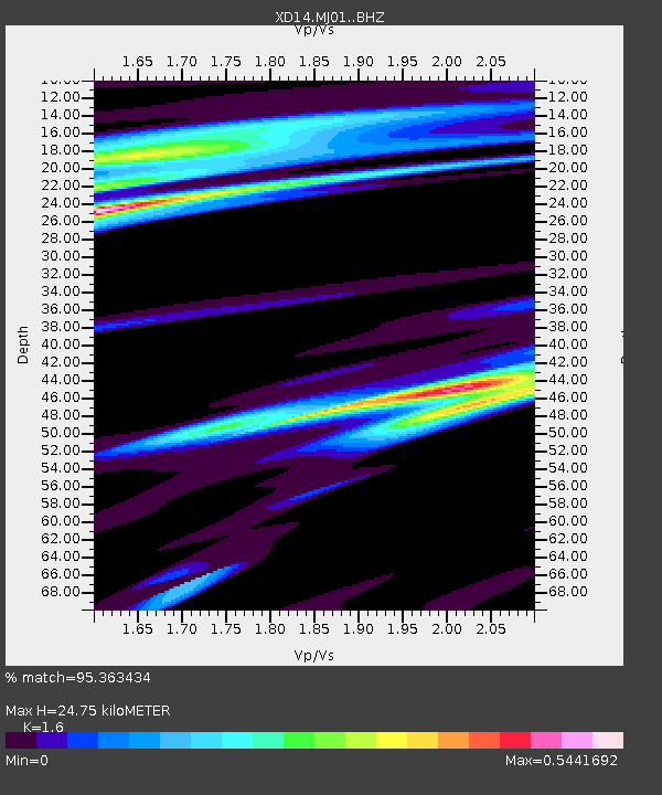
| Estimated Moho Depth: |
24.75 km |
| Estimated Crust Vp/Vs: |
1.60 |
| Assumed Crust Vp: |
6.566 km/s |
| Estimated Crust Vs: |
4.104 km/s |
| Estimated Crust Poisson's Ratio: |
0.18 |
|
| Radial Match: |
95.363434 % |
| Radial Bump: |
252 |
| Transverse Match: |
84.79 % |
| Transverse Bump: |
400 |
| SOD ConfigId: |
3390531 |
| Insert Time: |
2019-04-14 10:24:10.290 +0000 |
| GWidth: |
2.5 |
| Max Bumps: |
400 |
| Tol: |
0.001 |
|

Signal To Noise
| Channel | StoN | STA | LTA |
| XD:MJ01: :BHZ:20141009T02:26:02.555015Z | 13.597133 | 2.6251055E-6 | 1.9306317E-7 |
| XD:MJ01: :BHN:20141009T02:26:02.555015Z | 6.6116796 | 9.693346E-7 | 1.4660942E-7 |
| XD:MJ01: :BHE:20141009T02:26:02.555015Z | 1.6142585 | 3.5796623E-7 | 2.2175271E-7 |
| Arrivals |
| Ps | 2.3 SECOND |
| PpPs | 9.5 SECOND |
| PsPs/PpSs | 12 SECOND |


