You are here: Home > Network List > XD14 - Illuminating the architecture of the greater Mount St. Helens magmatic systems f Stations List
> Station ML03 "Mount St Helens, WA" > Earthquake Result Viewer
ML03 "Mount St Helens, WA" - Earthquake Result Viewer
| Earthquake location: |
Southern East Pacific Rise |
| Earthquake latitude/longitude: |
-32.1/-110.8 |
| Earthquake time(UTC): |
2014/10/09 (282) 02:14:32 GMT |
| Earthquake Depth: |
16 km |
| Earthquake Magnitude: |
7.1 MWW, 6.8 MI |
| Earthquake Catalog/Contributor: |
NEIC PDE/NEIC COMCAT |
|
| Network: |
XD Illuminating the architecture of the greater Mount St. Helens magmatic systems f |
| Station: |
ML03 "Mount St Helens, WA" |
| Lat/Lon: |
46.06 N/122.52 W |
| Elevation: |
356 m |
|
| Distance: |
78.5 deg |
| Az: |
351.69 deg |
| Baz: |
169.855 deg |
| Ray Param: |
0.049565233 |
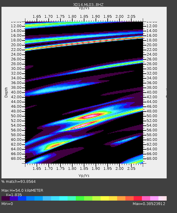
| Estimated Moho Depth: |
54.0 km |
| Estimated Crust Vp/Vs: |
1.84 |
| Assumed Crust Vp: |
6.566 km/s |
| Estimated Crust Vs: |
3.578 km/s |
| Estimated Crust Poisson's Ratio: |
0.29 |
|
| Radial Match: |
93.8564 % |
| Radial Bump: |
214 |
| Transverse Match: |
90.6673 % |
| Transverse Bump: |
383 |
| SOD ConfigId: |
3390531 |
| Insert Time: |
2019-04-14 10:24:17.842 +0000 |
| GWidth: |
2.5 |
| Max Bumps: |
400 |
| Tol: |
0.001 |
|

Signal To Noise
| Channel | StoN | STA | LTA |
| XD:ML03: :BHZ:20141009T02:26:01.64498Z | 21.068007 | 2.3331766E-6 | 1.1074501E-7 |
| XD:ML03: :BHN:20141009T02:26:01.64498Z | 8.741412 | 8.080813E-7 | 9.244288E-8 |
| XD:ML03: :BHE:20141009T02:26:01.64498Z | 3.140479 | 7.608218E-7 | 2.4226298E-7 |
| Arrivals |
| Ps | 7.1 SECOND |
| PpPs | 23 SECOND |
| PsPs/PpSs | 30 SECOND |


