You are here: Home > Network List > XD14 - Illuminating the architecture of the greater Mount St. Helens magmatic systems f Stations List
> Station ML09 "Mount St Helens, WA" > Earthquake Result Viewer
ML09 "Mount St Helens, WA" - Earthquake Result Viewer
| Earthquake location: |
Southern East Pacific Rise |
| Earthquake latitude/longitude: |
-32.1/-110.8 |
| Earthquake time(UTC): |
2014/10/09 (282) 02:14:32 GMT |
| Earthquake Depth: |
16 km |
| Earthquake Magnitude: |
7.1 MWW, 6.8 MI |
| Earthquake Catalog/Contributor: |
NEIC PDE/NEIC COMCAT |
|
| Network: |
XD Illuminating the architecture of the greater Mount St. Helens magmatic systems f |
| Station: |
ML09 "Mount St Helens, WA" |
| Lat/Lon: |
46.08 N/121.88 W |
| Elevation: |
1144 m |
|
| Distance: |
78.5 deg |
| Az: |
352.138 deg |
| Baz: |
170.401 deg |
| Ray Param: |
0.04960639 |
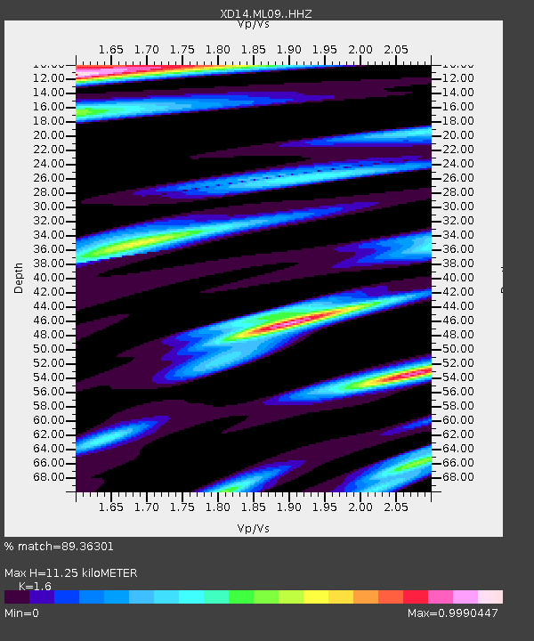
| Estimated Moho Depth: |
11.25 km |
| Estimated Crust Vp/Vs: |
1.60 |
| Assumed Crust Vp: |
6.597 km/s |
| Estimated Crust Vs: |
4.123 km/s |
| Estimated Crust Poisson's Ratio: |
0.18 |
|
| Radial Match: |
89.36301 % |
| Radial Bump: |
400 |
| Transverse Match: |
86.827194 % |
| Transverse Bump: |
400 |
| SOD ConfigId: |
3390531 |
| Insert Time: |
2019-04-14 10:24:21.079 +0000 |
| GWidth: |
2.5 |
| Max Bumps: |
400 |
| Tol: |
0.001 |
|

Signal To Noise
| Channel | StoN | STA | LTA |
| XD:ML09: :HHZ:20141009T02:26:01.320029Z | 16.665398 | 2.3841624E-6 | 1.4306063E-7 |
| XD:ML09: :HHN:20141009T02:26:01.320029Z | 6.2051845 | 9.578597E-7 | 1.5436441E-7 |
| XD:ML09: :HHE:20141009T02:26:01.320029Z | 0.87428594 | 3.1859645E-7 | 3.644076E-7 |
| Arrivals |
| Ps | 1.1 SECOND |
| PpPs | 4.3 SECOND |
| PsPs/PpSs | 5.3 SECOND |


