You are here: Home > Network List > IU - Global Seismograph Network (GSN - IRIS/USGS) Stations List
> Station TATO Taipei, Taiwan > Earthquake Result Viewer
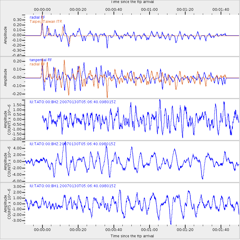
TATO Taipei, Taiwan - Earthquake Result Viewer
*The percent match for this event was below the threshold and hence no stack was calculated.
| Earthquake location: |
West Of Macquarie Island |
| Earthquake latitude/longitude: |
-54.7/146.3 |
| Earthquake time(UTC): |
2007/01/30 (030) 04:54:50 GMT |
| Earthquake Depth: |
11 km |
| Earthquake Magnitude: |
6.2 MB, 6.9 MS, 6.8 MW, 6.8 MW |
| Earthquake Catalog/Contributor: |
WHDF/NEIC |
|
| Network: |
IU Global Seismograph Network (GSN - IRIS/USGS) |
| Station: |
TATO Taipei, Taiwan |
| Lat/Lon: |
24.98 N/121.49 E |
| Elevation: |
53 m |
|
| Distance: |
82.2 deg |
| Az: |
337.395 deg |
| Baz: |
165.783 deg |
| Ray Param: |
$rayparam |
*The percent match for this event was below the threshold and hence was not used in the summary stack. |
|
| Radial Match: |
87.393684 % |
| Radial Bump: |
400 |
| Transverse Match: |
73.41416 % |
| Transverse Bump: |
400 |
| SOD ConfigId: |
590571 |
| Insert Time: |
2013-09-26 06:11:13.105 +0000 |
| GWidth: |
2.5 |
| Max Bumps: |
400 |
| Tol: |
0.001 |
|
Signal To Noise
| Channel | StoN | STA | LTA |
| IU:TATO:00:BHZ:20070130T05:06:40.098015Z | 3.0729096 | 1.0546696E-6 | 3.4321528E-7 |
| IU:TATO:00:BH1:20070130T05:06:40.098015Z | 1.3693475 | 5.452217E-7 | 3.981617E-7 |
| IU:TATO:00:BH2:20070130T05:06:40.098015Z | 0.9660997 | 4.249651E-7 | 4.3987706E-7 |
| Arrivals |
| Ps | |
| PpPs | |
| PsPs/PpSs | |


