You are here: Home > Network List > GS - US Geological Survey Networks Stations List
> Station KAN09 Caldwell North Station > Earthquake Result Viewer
KAN09 Caldwell North Station - Earthquake Result Viewer

| Earthquake location: |
Southern East Pacific Rise |
| Earthquake latitude/longitude: |
-32.1/-110.9 |
| Earthquake time(UTC): |
2014/10/09 (282) 02:32:05 GMT |
| Earthquake Depth: |
10 km |
| Earthquake Magnitude: |
6.6 MWW, 6.6 MWC |
| Earthquake Catalog/Contributor: |
NEIC PDE/NEIC COMCAT |
|
| Network: |
GS US Geological Survey Networks |
| Station: |
KAN09 Caldwell North Station |
| Lat/Lon: |
37.14 N/97.62 W |
| Elevation: |
371 m |
|
| Distance: |
70.0 deg |
| Az: |
11.259 deg |
| Baz: |
191.966 deg |
| Ray Param: |
0.055276405 |
| Estimated Moho Depth: |
29.75 km |
| Estimated Crust Vp/Vs: |
1.75 |
| Assumed Crust Vp: |
6.483 km/s |
| Estimated Crust Vs: |
3.715 km/s |
| Estimated Crust Poisson's Ratio: |
0.26 |
|
| Radial Match: |
91.310356 % |
| Radial Bump: |
98 |
| Transverse Match: |
45.552437 % |
| Transverse Bump: |
193 |
| SOD ConfigId: |
3390531 |
| Insert Time: |
2019-04-14 10:29:23.559 +0000 |
| GWidth: |
2.5 |
| Max Bumps: |
400 |
| Tol: |
0.001 |
|
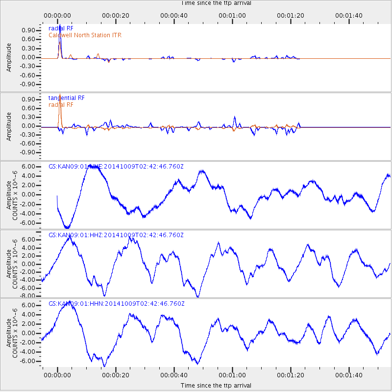
Signal To Noise
| Channel | StoN | STA | LTA |
| GS:KAN09:01:HHZ:20141009T02:42:46.760Z | 3.337775 | 5.2838664E-6 | 1.5830504E-6 |
| GS:KAN09:01:HHN:20141009T02:42:46.760Z | 3.240724 | 6.1334385E-6 | 1.8926136E-6 |
| GS:KAN09:01:HHE:20141009T02:42:46.760Z | 0.8458672 | 3.6110816E-6 | 4.269088E-6 |
| Arrivals |
| Ps | 3.6 SECOND |
| PpPs | 12 SECOND |
| PsPs/PpSs | 16 SECOND |


