You are here: Home > Network List > IU - Global Seismograph Network (GSN - IRIS/USGS) Stations List
> Station RSSD Black Hills, South Dakota, USA > Earthquake Result Viewer
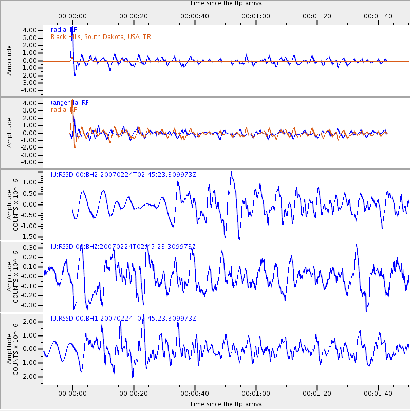
RSSD Black Hills, South Dakota, USA - Earthquake Result Viewer
*The percent match for this event was below the threshold and hence no stack was calculated.
| Earthquake location: |
Off Coast Of Northern Peru |
| Earthquake latitude/longitude: |
-7.0/-80.5 |
| Earthquake time(UTC): |
2007/02/24 (055) 02:36:23 GMT |
| Earthquake Depth: |
23 km |
| Earthquake Magnitude: |
6.3 MW, 5.9 MB, 6.1 MS, 6.3 MW |
| Earthquake Catalog/Contributor: |
NEIC PDE/NEIC PDE-M |
|
| Network: |
IU Global Seismograph Network (GSN - IRIS/USGS) |
| Station: |
RSSD Black Hills, South Dakota, USA |
| Lat/Lon: |
44.12 N/104.04 W |
| Elevation: |
2060 m |
|
| Distance: |
55.2 deg |
| Az: |
339.474 deg |
| Baz: |
151.102 deg |
| Ray Param: |
$rayparam |
*The percent match for this event was below the threshold and hence was not used in the summary stack. |
|
| Radial Match: |
53.719093 % |
| Radial Bump: |
400 |
| Transverse Match: |
54.01555 % |
| Transverse Bump: |
400 |
| SOD ConfigId: |
590571 |
| Insert Time: |
2013-09-26 07:09:52.957 +0000 |
| GWidth: |
2.5 |
| Max Bumps: |
400 |
| Tol: |
0.001 |
|
Signal To Noise
| Channel | StoN | STA | LTA |
| IU:RSSD:00:BHZ:20070224T02:45:23.309973Z | 5.8187532 | 2.2319365E-7 | 3.835764E-8 |
| IU:RSSD:00:BH1:20070224T02:45:23.309973Z | 2.451621 | 7.724637E-7 | 3.1508281E-7 |
| IU:RSSD:00:BH2:20070224T02:45:23.309973Z | 1.825435 | 6.164514E-7 | 3.377011E-7 |
| Arrivals |
| Ps | |
| PpPs | |
| PsPs/PpSs | |


