You are here: Home > Network List > IU - Global Seismograph Network (GSN - IRIS/USGS) Stations List
> Station RSSD Black Hills, South Dakota, USA > Earthquake Result Viewer
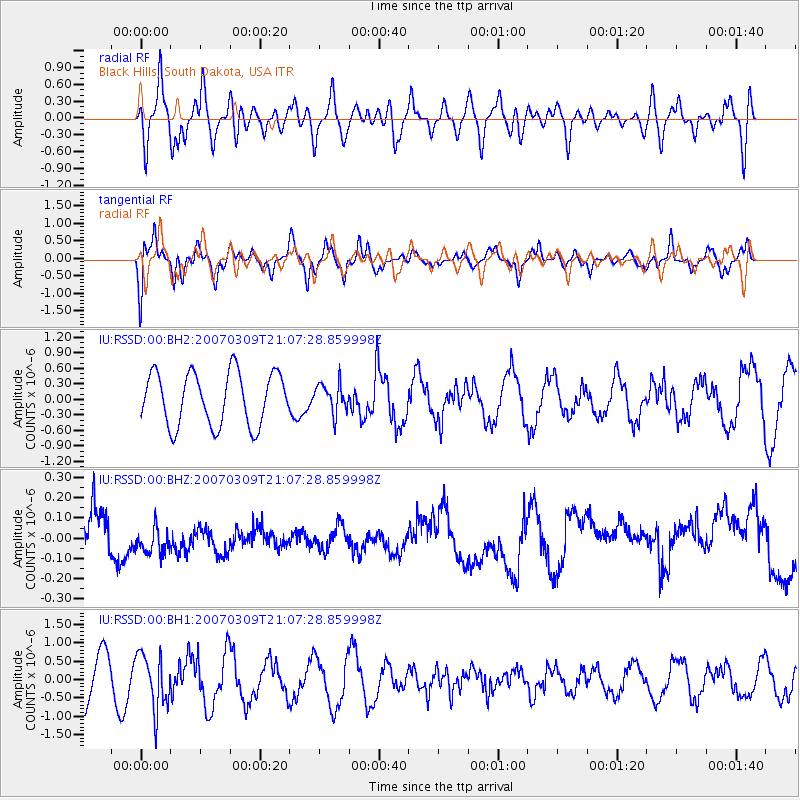
RSSD Black Hills, South Dakota, USA - Earthquake Result Viewer
*The percent match for this event was below the threshold and hence no stack was calculated.
| Earthquake location: |
Honduras |
| Earthquake latitude/longitude: |
13.3/-87.4 |
| Earthquake time(UTC): |
2007/03/09 (068) 21:01:37 GMT |
| Earthquake Depth: |
226 km |
| Earthquake Magnitude: |
5.6 MW, 5.2 MB, 5.5 MW |
| Earthquake Catalog/Contributor: |
WHDF/NEIC |
|
| Network: |
IU Global Seismograph Network (GSN - IRIS/USGS) |
| Station: |
RSSD Black Hills, South Dakota, USA |
| Lat/Lon: |
44.12 N/104.04 W |
| Elevation: |
2060 m |
|
| Distance: |
33.9 deg |
| Az: |
338.288 deg |
| Baz: |
149.991 deg |
| Ray Param: |
$rayparam |
*The percent match for this event was below the threshold and hence was not used in the summary stack. |
|
| Radial Match: |
24.895771 % |
| Radial Bump: |
400 |
| Transverse Match: |
31.665316 % |
| Transverse Bump: |
354 |
| SOD ConfigId: |
590571 |
| Insert Time: |
2013-09-26 07:44:59.148 +0000 |
| GWidth: |
2.5 |
| Max Bumps: |
400 |
| Tol: |
0.001 |
|
Signal To Noise
| Channel | StoN | STA | LTA |
| IU:RSSD:00:BHZ:20070309T21:07:28.859998Z | 0.68066967 | 7.075531E-8 | 1.0394957E-7 |
| IU:RSSD:00:BH1:20070309T21:07:28.859998Z | 1.4720128 | 7.506096E-7 | 5.099206E-7 |
| IU:RSSD:00:BH2:20070309T21:07:28.859998Z | 0.5586295 | 2.8313482E-7 | 5.068383E-7 |
| Arrivals |
| Ps | |
| PpPs | |
| PsPs/PpSs | |


