You are here: Home > Network List > ZJ12 - Transantarctic Mountains Northern Network Stations List
> Station SHRD Lister Nunataks, Antarctica > Earthquake Result Viewer
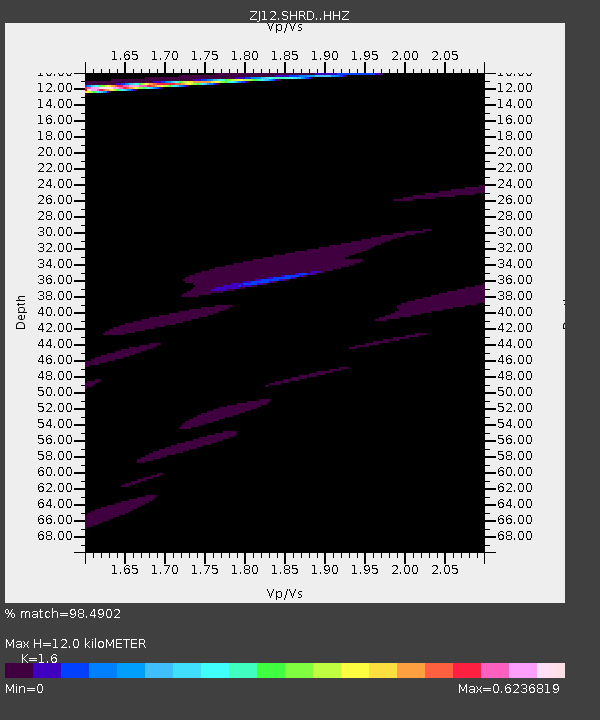
SHRD Lister Nunataks, Antarctica - Earthquake Result Viewer
| Earthquake location: |
Southern East Pacific Rise |
| Earthquake latitude/longitude: |
-32.1/-110.9 |
| Earthquake time(UTC): |
2014/10/09 (282) 02:32:05 GMT |
| Earthquake Depth: |
10 km |
| Earthquake Magnitude: |
6.6 MWW, 6.6 MWC |
| Earthquake Catalog/Contributor: |
NEIC PDE/NEIC COMCAT |
|
| Network: |
ZJ Transantarctic Mountains Northern Network |
| Station: |
SHRD Lister Nunataks, Antarctica |
| Lat/Lon: |
73.40 S/160.50 E |
| Elevation: |
2457 m |
|
| Distance: |
59.2 deg |
| Az: |
199.554 deg |
| Baz: |
98.868 deg |
| Ray Param: |
0.062368598 |
| Estimated Moho Depth: |
12.0 km |
| Estimated Crust Vp/Vs: |
1.60 |
| Assumed Crust Vp: |
6.264 km/s |
| Estimated Crust Vs: |
3.915 km/s |
| Estimated Crust Poisson's Ratio: |
0.18 |
|
| Radial Match: |
98.4902 % |
| Radial Bump: |
250 |
| Transverse Match: |
81.15173 % |
| Transverse Bump: |
369 |
| SOD ConfigId: |
3390531 |
| Insert Time: |
2019-04-14 10:35:19.201 +0000 |
| GWidth: |
2.5 |
| Max Bumps: |
400 |
| Tol: |
0.001 |
|

Signal To Noise
| Channel | StoN | STA | LTA |
| ZJ:SHRD: :HHZ:20141009T02:41:35.429006Z | 1.5213326 | 5.709452E-6 | 3.7529283E-6 |
| ZJ:SHRD: :HHN:20141009T02:41:35.429006Z | 1.7838308 | 5.963253E-6 | 3.3429478E-6 |
| ZJ:SHRD: :HHE:20141009T02:41:35.429006Z | 6.897405 | 1.0152458E-5 | 1.4719243E-6 |
| Arrivals |
| Ps | 1.2 SECOND |
| PpPs | 4.7 SECOND |
| PsPs/PpSs | 5.9 SECOND |


