You are here: Home > Network List > TA - USArray Transportable Network (new EarthScope stations) Stations List
> Station H17A Grant Village (NPS), Yellowstone Nt. Park, WY, USA > Earthquake Result Viewer
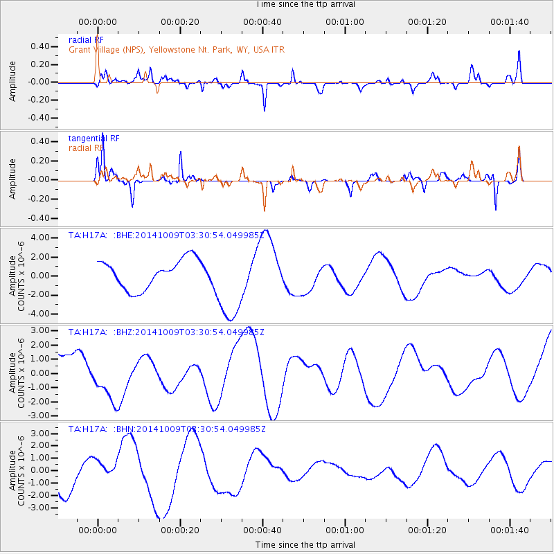
H17A Grant Village (NPS), Yellowstone Nt. Park, WY, USA - Earthquake Result Viewer
*The percent match for this event was below the threshold and hence no stack was calculated.
| Earthquake location: |
Southern East Pacific Rise |
| Earthquake latitude/longitude: |
-32.1/-110.7 |
| Earthquake time(UTC): |
2014/10/09 (282) 03:19:37 GMT |
| Earthquake Depth: |
10 km |
| Earthquake Magnitude: |
5.2 mb |
| Earthquake Catalog/Contributor: |
ISC/ISC |
|
| Network: |
TA USArray Transportable Network (new EarthScope stations) |
| Station: |
H17A Grant Village (NPS), Yellowstone Nt. Park, WY, USA |
| Lat/Lon: |
44.40 N/110.58 W |
| Elevation: |
2400 m |
|
| Distance: |
76.2 deg |
| Az: |
0.123 deg |
| Baz: |
180.146 deg |
| Ray Param: |
$rayparam |
*The percent match for this event was below the threshold and hence was not used in the summary stack. |
|
| Radial Match: |
34.153343 % |
| Radial Bump: |
228 |
| Transverse Match: |
60.206676 % |
| Transverse Bump: |
228 |
| SOD ConfigId: |
3390531 |
| Insert Time: |
2019-04-14 10:41:12.210 +0000 |
| GWidth: |
2.5 |
| Max Bumps: |
400 |
| Tol: |
0.001 |
|
Signal To Noise
| Channel | StoN | STA | LTA |
| TA:H17A: :BHZ:20141009T03:30:54.049985Z | 1.3885412 | 1.7044268E-6 | 1.2274945E-6 |
| TA:H17A: :BHN:20141009T03:30:54.049985Z | 0.86704695 | 8.283415E-7 | 9.553595E-7 |
| TA:H17A: :BHE:20141009T03:30:54.049985Z | 2.7582824 | 4.1374296E-6 | 1.5000022E-6 |
| Arrivals |
| Ps | |
| PpPs | |
| PsPs/PpSs | |


