You are here: Home > Network List > TA - USArray Transportable Network (new EarthScope stations) Stations List
> Station O48A Farmland, IN, USA > Earthquake Result Viewer
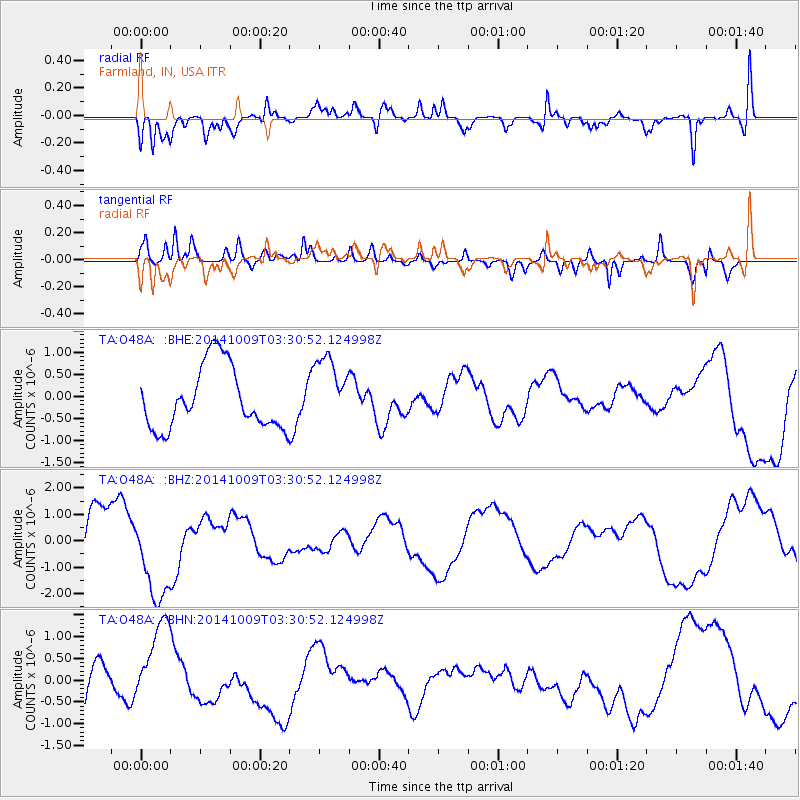
O48A Farmland, IN, USA - Earthquake Result Viewer
*The percent match for this event was below the threshold and hence no stack was calculated.
| Earthquake location: |
Southern East Pacific Rise |
| Earthquake latitude/longitude: |
-32.1/-110.7 |
| Earthquake time(UTC): |
2014/10/09 (282) 03:19:37 GMT |
| Earthquake Depth: |
10 km |
| Earthquake Magnitude: |
5.2 mb |
| Earthquake Catalog/Contributor: |
ISC/ISC |
|
| Network: |
TA USArray Transportable Network (new EarthScope stations) |
| Station: |
O48A Farmland, IN, USA |
| Lat/Lon: |
40.26 N/85.16 W |
| Elevation: |
300 m |
|
| Distance: |
75.8 deg |
| Az: |
19.931 deg |
| Baz: |
202.203 deg |
| Ray Param: |
$rayparam |
*The percent match for this event was below the threshold and hence was not used in the summary stack. |
|
| Radial Match: |
62.65349 % |
| Radial Bump: |
400 |
| Transverse Match: |
63.998558 % |
| Transverse Bump: |
400 |
| SOD ConfigId: |
3390531 |
| Insert Time: |
2019-04-14 10:41:32.323 +0000 |
| GWidth: |
2.5 |
| Max Bumps: |
400 |
| Tol: |
0.001 |
|
Signal To Noise
| Channel | StoN | STA | LTA |
| TA:O48A: :BHZ:20141009T03:30:52.124998Z | 2.1059985 | 1.6817804E-6 | 7.9856676E-7 |
| TA:O48A: :BHN:20141009T03:30:52.124998Z | 1.9229165 | 1.0357342E-6 | 5.386267E-7 |
| TA:O48A: :BHE:20141009T03:30:52.124998Z | 1.1195725 | 7.914511E-7 | 7.0692255E-7 |
| Arrivals |
| Ps | |
| PpPs | |
| PsPs/PpSs | |


