You are here: Home > Network List > US - United States National Seismic Network Stations List
> Station KSU1 Kansas State University--Konza Prairie, Kansas, USA > Earthquake Result Viewer
KSU1 Kansas State University--Konza Prairie, Kansas, USA - Earthquake Result Viewer
| Earthquake location: |
Azores Islands Region |
| Earthquake latitude/longitude: |
37.3/-24.6 |
| Earthquake time(UTC): |
2007/04/05 (095) 03:56:50 GMT |
| Earthquake Depth: |
14 km |
| Earthquake Magnitude: |
6.1 MB, 6.2 MS, 6.3 MW, 6.2 MW |
| Earthquake Catalog/Contributor: |
WHDF/NEIC |
|
| Network: |
US United States National Seismic Network |
| Station: |
KSU1 Kansas State University--Konza Prairie, Kansas, USA |
| Lat/Lon: |
39.10 N/96.61 W |
| Elevation: |
347 m |
|
| Distance: |
55.2 deg |
| Az: |
295.67 deg |
| Baz: |
67.46 deg |
| Ray Param: |
0.06495022 |
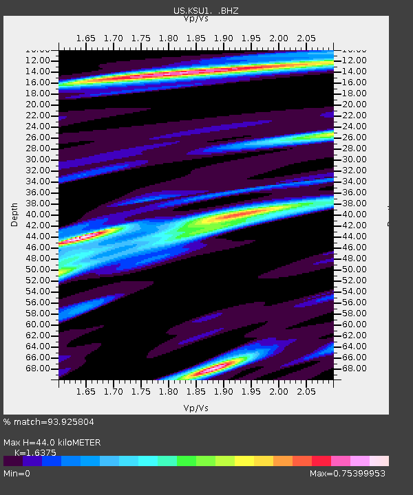
| Estimated Moho Depth: |
44.0 km |
| Estimated Crust Vp/Vs: |
1.64 |
| Assumed Crust Vp: |
6.483 km/s |
| Estimated Crust Vs: |
3.959 km/s |
| Estimated Crust Poisson's Ratio: |
0.20 |
|
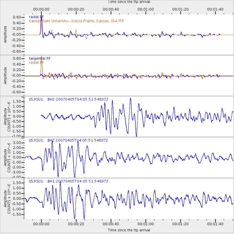
| Radial Match: |
93.925804 % |
| Radial Bump: |
291 |
| Transverse Match: |
71.87782 % |
| Transverse Bump: |
400 |
| SOD ConfigId: |
590571 |
| Insert Time: |
2013-09-26 09:51:46.918 +0000 |
| GWidth: |
2.5 |
| Max Bumps: |
400 |
| Tol: |
0.001 |
|
Signal To Noise
| Channel | StoN | STA | LTA |
| US:KSU1: :BHZ:20070405T04:05:51.54897Z | 6.4100947 | 1.254645E-6 | 1.9572954E-7 |
| US:KSU1: :BH1:20070405T04:05:51.54897Z | 3.201745 | 5.465927E-7 | 1.7071712E-7 |
| US:KSU1: :BH2:20070405T04:05:51.54897Z | 3.5479724 | 5.426245E-7 | 1.5293932E-7 |
| Arrivals |
| Ps | 4.6 SECOND |
| PpPs | 17 SECOND |
| PsPs/PpSs | 21 SECOND |


