You are here: Home > Network List > IU - Global Seismograph Network (GSN - IRIS/USGS) Stations List
> Station RSSD Black Hills, South Dakota, USA > Earthquake Result Viewer
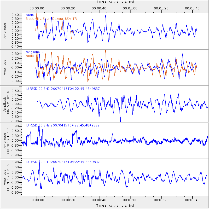
RSSD Black Hills, South Dakota, USA - Earthquake Result Viewer
*The percent match for this event was below the threshold and hence no stack was calculated.
| Earthquake location: |
Kuril Islands |
| Earthquake latitude/longitude: |
47.0/153.4 |
| Earthquake time(UTC): |
2007/04/15 (105) 04:12:30 GMT |
| Earthquake Depth: |
35 km |
| Earthquake Magnitude: |
5.6 MB, 5.0 MS, 5.5 MW, 5.5 MW |
| Earthquake Catalog/Contributor: |
WHDF/NEIC |
|
| Network: |
IU Global Seismograph Network (GSN - IRIS/USGS) |
| Station: |
RSSD Black Hills, South Dakota, USA |
| Lat/Lon: |
44.12 N/104.04 W |
| Elevation: |
2060 m |
|
| Distance: |
66.5 deg |
| Az: |
50.058 deg |
| Baz: |
313.232 deg |
| Ray Param: |
$rayparam |
*The percent match for this event was below the threshold and hence was not used in the summary stack. |
|
| Radial Match: |
69.206215 % |
| Radial Bump: |
400 |
| Transverse Match: |
50.99838 % |
| Transverse Bump: |
400 |
| SOD ConfigId: |
590571 |
| Insert Time: |
2013-09-26 10:17:08.695 +0000 |
| GWidth: |
2.5 |
| Max Bumps: |
400 |
| Tol: |
0.001 |
|
Signal To Noise
| Channel | StoN | STA | LTA |
| IU:RSSD:00:BHZ:20070415T04:22:45.484983Z | 1.373116 | 4.0997244E-7 | 2.9857088E-7 |
| IU:RSSD:00:BH1:20070415T04:22:45.484983Z | 2.5010157 | 4.316508E-7 | 1.725902E-7 |
| IU:RSSD:00:BH2:20070415T04:22:45.484983Z | 1.0441325 | 1.5189846E-7 | 1.4547815E-7 |
| Arrivals |
| Ps | |
| PpPs | |
| PsPs/PpSs | |


