You are here: Home > Network List > GS - US Geological Survey Networks Stations List
> Station KAN10 Keim Farm > Earthquake Result Viewer
KAN10 Keim Farm - Earthquake Result Viewer
*The percent match for this event was below the threshold and hence no stack was calculated.
| Earthquake location: |
Southern East Pacific Rise |
| Earthquake latitude/longitude: |
-32.2/-110.8 |
| Earthquake time(UTC): |
2014/10/10 (283) 04:07:51 GMT |
| Earthquake Depth: |
10 km |
| Earthquake Magnitude: |
5.5 MWP |
| Earthquake Catalog/Contributor: |
NEIC PDE/NEIC COMCAT |
|
| Network: |
GS US Geological Survey Networks |
| Station: |
KAN10 Keim Farm |
| Lat/Lon: |
37.12 N/98.10 W |
| Elevation: |
417 m |
|
| Distance: |
70.0 deg |
| Az: |
10.788 deg |
| Baz: |
191.451 deg |
| Ray Param: |
$rayparam |
*The percent match for this event was below the threshold and hence was not used in the summary stack. |
|
| Radial Match: |
32.957466 % |
| Radial Bump: |
400 |
| Transverse Match: |
49.174576 % |
| Transverse Bump: |
400 |
| SOD ConfigId: |
3390531 |
| Insert Time: |
2019-04-14 11:06:38.583 +0000 |
| GWidth: |
2.5 |
| Max Bumps: |
400 |
| Tol: |
0.001 |
|
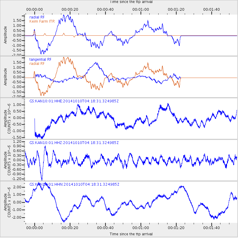
Signal To Noise
| Channel | StoN | STA | LTA |
| GS:KAN10:01:HHZ:20141010T04:18:31.324985Z | 3.2363117 | 5.5954035E-7 | 1.7289446E-7 |
| GS:KAN10:01:HHN:20141010T04:18:31.324985Z | 2.348628 | 2.7718456E-6 | 1.1801977E-6 |
| GS:KAN10:01:HHE:20141010T04:18:31.324985Z | 1.3380599 | 9.125203E-7 | 6.819727E-7 |
| Arrivals |
| Ps | |
| PpPs | |
| PsPs/PpSs | |


