You are here: Home > Network List > CI - Caltech Regional Seismic Network Stations List
> Station TIN Tinemaha, California, USA > Earthquake Result Viewer
TIN Tinemaha, California, USA - Earthquake Result Viewer
| Earthquake location: |
Iceland |
| Earthquake latitude/longitude: |
64.0/-20.8 |
| Earthquake time(UTC): |
2000/06/21 (173) 00:51:46 GMT |
| Earthquake Depth: |
10 km |
| Earthquake Magnitude: |
6.1 MB, 6.6 MS, 6.5 MW, 6.4 MW |
| Earthquake Catalog/Contributor: |
WHDF/NEIC |
|
| Network: |
CI Caltech Regional Seismic Network |
| Station: |
TIN Tinemaha, California, USA |
| Lat/Lon: |
37.05 N/118.23 W |
| Elevation: |
1164 m |
|
| Distance: |
60.5 deg |
| Az: |
294.291 deg |
| Baz: |
30.167 deg |
| Ray Param: |
0.061498716 |
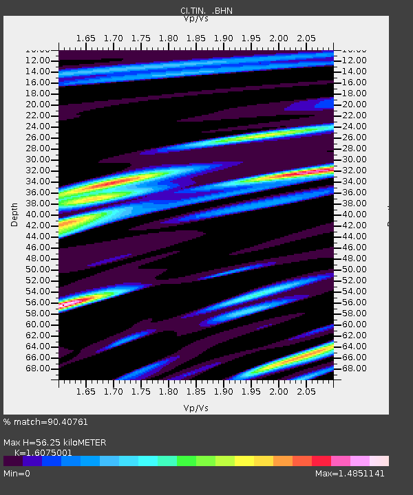
| Estimated Moho Depth: |
56.25 km |
| Estimated Crust Vp/Vs: |
1.61 |
| Assumed Crust Vp: |
6.291 km/s |
| Estimated Crust Vs: |
3.914 km/s |
| Estimated Crust Poisson's Ratio: |
0.18 |
|
| Radial Match: |
90.40761 % |
| Radial Bump: |
400 |
| Transverse Match: |
78.59206 % |
| Transverse Bump: |
400 |
| SOD ConfigId: |
3744 |
| Insert Time: |
2010-02-25 20:45:48.692 +0000 |
| GWidth: |
2.5 |
| Max Bumps: |
400 |
| Tol: |
0.001 |
|
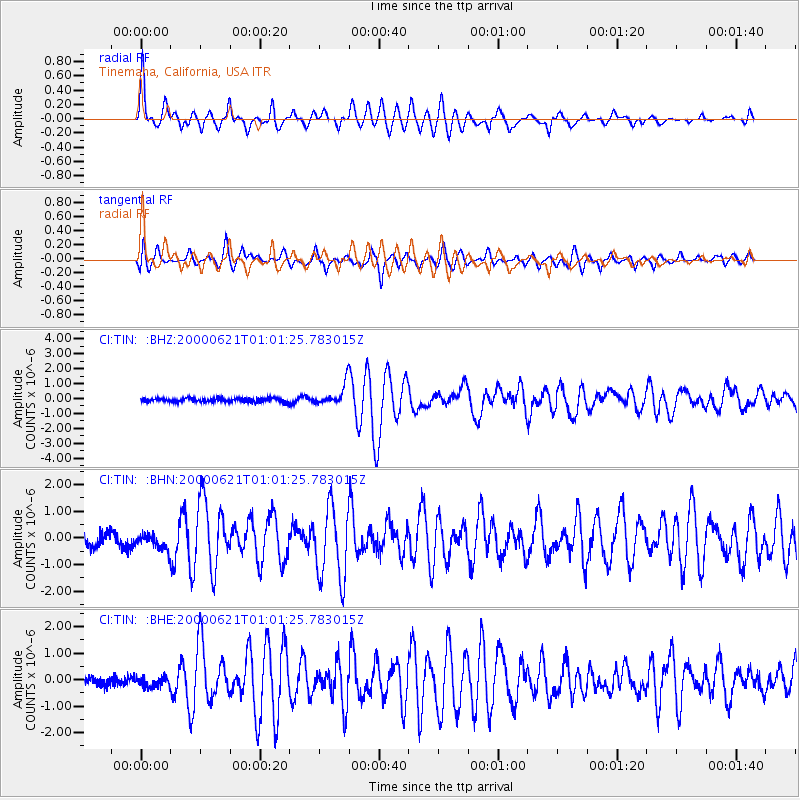
Signal To Noise
| Channel | StoN | STA | LTA |
| CI:TIN: :BHN:20000621T01:01:25.783015Z | 1.2297982 | 2.942329E-7 | 2.3925298E-7 |
| CI:TIN: :BHE:20000621T01:01:25.783015Z | 1.0114856 | 2.011486E-7 | 1.9886454E-7 |
| CI:TIN: :BHZ:20000621T01:01:25.783015Z | 5.462566 | 6.914049E-7 | 1.2657146E-7 |
| Arrivals |
| Ps | 5.7 SECOND |
| PpPs | 22 SECOND |
| PsPs/PpSs | 28 SECOND |


