You are here: Home > Network List > IU - Global Seismograph Network (GSN - IRIS/USGS) Stations List
> Station RSSD Black Hills, South Dakota, USA > Earthquake Result Viewer
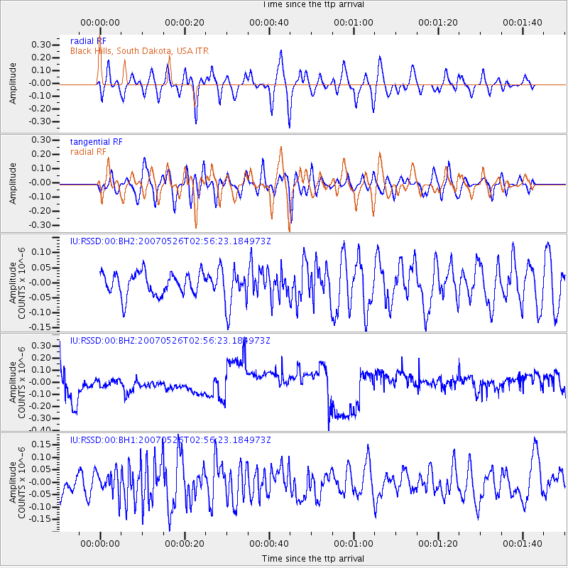
RSSD Black Hills, South Dakota, USA - Earthquake Result Viewer
*The percent match for this event was below the threshold and hence no stack was calculated.
| Earthquake location: |
Southern Pacific Ocean |
| Earthquake latitude/longitude: |
-35.9/-103.1 |
| Earthquake time(UTC): |
2007/05/26 (146) 02:44:46 GMT |
| Earthquake Depth: |
10 km |
| Earthquake Magnitude: |
5.5 MW, 5.1 MB |
| Earthquake Catalog/Contributor: |
WHDF/NEIC |
|
| Network: |
IU Global Seismograph Network (GSN - IRIS/USGS) |
| Station: |
RSSD Black Hills, South Dakota, USA |
| Lat/Lon: |
44.12 N/104.04 W |
| Elevation: |
2060 m |
|
| Distance: |
79.7 deg |
| Az: |
359.312 deg |
| Baz: |
179.225 deg |
| Ray Param: |
$rayparam |
*The percent match for this event was below the threshold and hence was not used in the summary stack. |
|
| Radial Match: |
53.69482 % |
| Radial Bump: |
400 |
| Transverse Match: |
46.12664 % |
| Transverse Bump: |
400 |
| SOD ConfigId: |
590571 |
| Insert Time: |
2013-09-26 11:50:38.525 +0000 |
| GWidth: |
2.5 |
| Max Bumps: |
400 |
| Tol: |
0.001 |
|
Signal To Noise
| Channel | StoN | STA | LTA |
| IU:RSSD:00:BHZ:20070526T02:56:23.184973Z | 0.41042164 | 4.91417E-8 | 1.1973468E-7 |
| IU:RSSD:00:BH1:20070526T02:56:23.184973Z | 0.94773614 | 4.4864827E-8 | 4.733894E-8 |
| IU:RSSD:00:BH2:20070526T02:56:23.184973Z | 1.7837758 | 6.597721E-8 | 3.6987387E-8 |
| Arrivals |
| Ps | |
| PpPs | |
| PsPs/PpSs | |


