You are here: Home > Network List > IU - Global Seismograph Network (GSN - IRIS/USGS) Stations List
> Station RSSD Black Hills, South Dakota, USA > Earthquake Result Viewer
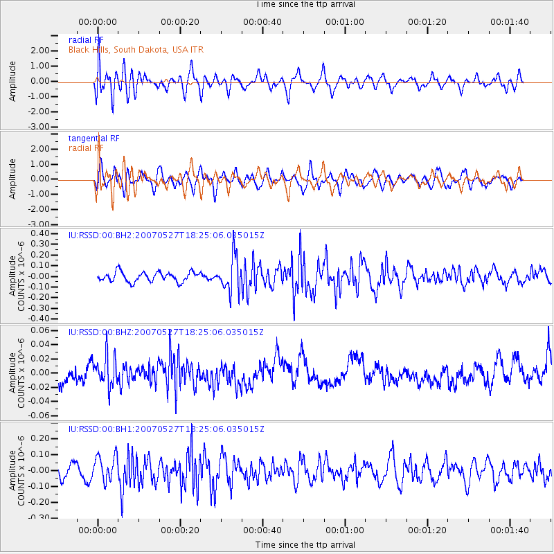
RSSD Black Hills, South Dakota, USA - Earthquake Result Viewer
*The percent match for this event was below the threshold and hence no stack was calculated.
| Earthquake location: |
Tonga Islands |
| Earthquake latitude/longitude: |
-20.1/-174.5 |
| Earthquake time(UTC): |
2007/05/27 (147) 18:12:34 GMT |
| Earthquake Depth: |
7.3 km |
| Earthquake Magnitude: |
5.8 MB, 5.1 MS, 5.6 MW, 5.5 MW |
| Earthquake Catalog/Contributor: |
WHDF/NEIC |
|
| Network: |
IU Global Seismograph Network (GSN - IRIS/USGS) |
| Station: |
RSSD Black Hills, South Dakota, USA |
| Lat/Lon: |
44.12 N/104.04 W |
| Elevation: |
2060 m |
|
| Distance: |
90.6 deg |
| Az: |
42.755 deg |
| Baz: |
242.382 deg |
| Ray Param: |
$rayparam |
*The percent match for this event was below the threshold and hence was not used in the summary stack. |
|
| Radial Match: |
58.44059 % |
| Radial Bump: |
400 |
| Transverse Match: |
53.35314 % |
| Transverse Bump: |
400 |
| SOD ConfigId: |
590571 |
| Insert Time: |
2013-09-26 11:52:06.489 +0000 |
| GWidth: |
2.5 |
| Max Bumps: |
400 |
| Tol: |
0.001 |
|
Signal To Noise
| Channel | StoN | STA | LTA |
| IU:RSSD:00:BHZ:20070527T18:25:06.035015Z | 1.4901314 | 2.1910537E-8 | 1.4703763E-8 |
| IU:RSSD:00:BH1:20070527T18:25:06.035015Z | 1.2090161 | 8.196202E-8 | 6.779233E-8 |
| IU:RSSD:00:BH2:20070527T18:25:06.035015Z | 3.7138088 | 1.685298E-7 | 4.5379235E-8 |
| Arrivals |
| Ps | |
| PpPs | |
| PsPs/PpSs | |


