You are here: Home > Network List > CI - Caltech Regional Seismic Network Stations List
> Station TIN Tinemaha, California, USA > Earthquake Result Viewer
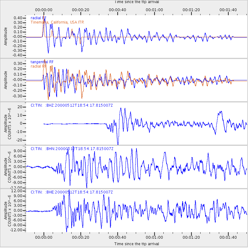
TIN Tinemaha, California, USA - Earthquake Result Viewer
| Earthquake location: |
Jujuy Province, Argentina |
| Earthquake latitude/longitude: |
-23.5/-66.5 |
| Earthquake time(UTC): |
2000/05/12 (133) 18:43:18 GMT |
| Earthquake Depth: |
225 km |
| Earthquake Magnitude: |
6.2 MB, 7.2 MW, 7.1 MW |
| Earthquake Catalog/Contributor: |
WHDF/NEIC |
|
| Network: |
CI Caltech Regional Seismic Network |
| Station: |
TIN Tinemaha, California, USA |
| Lat/Lon: |
37.05 N/118.23 W |
| Elevation: |
1164 m |
|
| Distance: |
77.5 deg |
| Az: |
319.933 deg |
| Baz: |
132.407 deg |
| Ray Param: |
0.049670063 |
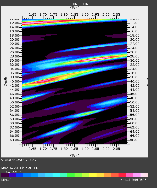
| Estimated Moho Depth: |
29.0 km |
| Estimated Crust Vp/Vs: |
1.95 |
| Assumed Crust Vp: |
6.291 km/s |
| Estimated Crust Vs: |
3.222 km/s |
| Estimated Crust Poisson's Ratio: |
0.32 |
|
| Radial Match: |
94.393425 % |
| Radial Bump: |
400 |
| Transverse Match: |
89.10834 % |
| Transverse Bump: |
400 |
| SOD ConfigId: |
3744 |
| Insert Time: |
2010-02-25 20:45:51.693 +0000 |
| GWidth: |
2.5 |
| Max Bumps: |
400 |
| Tol: |
0.001 |
|
Signal To Noise
| Channel | StoN | STA | LTA |
| CI:TIN: :BHN:20000512T18:54:17.815007Z | 1.4091194 | 3.7558792E-7 | 2.665409E-7 |
| CI:TIN: :BHE:20000512T18:54:17.815007Z | 2.2938116 | 3.4107413E-7 | 1.4869318E-7 |
| CI:TIN: :BHZ:20000512T18:54:17.815007Z | 7.756603 | 1.5808401E-6 | 2.0380574E-7 |
| Arrivals |
| Ps | 4.5 SECOND |
| PpPs | 13 SECOND |
| PsPs/PpSs | 18 SECOND |


