You are here: Home > Network List > IU - Global Seismograph Network (GSN - IRIS/USGS) Stations List
> Station RSSD Black Hills, South Dakota, USA > Earthquake Result Viewer
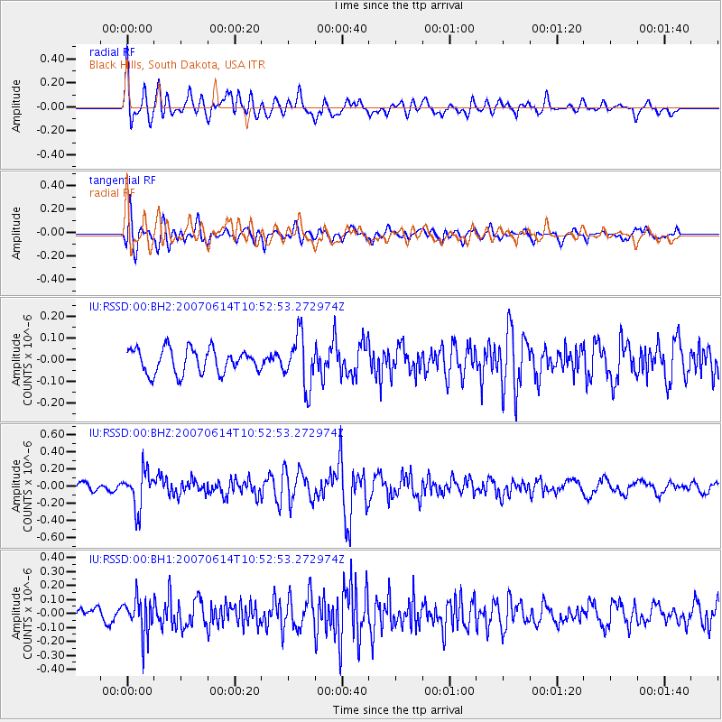
RSSD Black Hills, South Dakota, USA - Earthquake Result Viewer
*The percent match for this event was below the threshold and hence no stack was calculated.
| Earthquake location: |
Northern Chile |
| Earthquake latitude/longitude: |
-23.0/-68.9 |
| Earthquake time(UTC): |
2007/06/14 (165) 10:41:59 GMT |
| Earthquake Depth: |
105 km |
| Earthquake Magnitude: |
5.5 MW, 5.3 MB |
| Earthquake Catalog/Contributor: |
WHDF/NEIC |
|
| Network: |
IU Global Seismograph Network (GSN - IRIS/USGS) |
| Station: |
RSSD Black Hills, South Dakota, USA |
| Lat/Lon: |
44.12 N/104.04 W |
| Elevation: |
2060 m |
|
| Distance: |
74.2 deg |
| Az: |
334.489 deg |
| Baz: |
146.57 deg |
| Ray Param: |
$rayparam |
*The percent match for this event was below the threshold and hence was not used in the summary stack. |
|
| Radial Match: |
72.15424 % |
| Radial Bump: |
400 |
| Transverse Match: |
69.72656 % |
| Transverse Bump: |
400 |
| SOD ConfigId: |
590571 |
| Insert Time: |
2013-09-26 12:11:40.277 +0000 |
| GWidth: |
2.5 |
| Max Bumps: |
400 |
| Tol: |
0.001 |
|
Signal To Noise
| Channel | StoN | STA | LTA |
| IU:RSSD:00:BHZ:20070614T10:52:53.272974Z | 4.2743554 | 2.2013124E-7 | 5.1500454E-8 |
| IU:RSSD:00:BH1:20070614T10:52:53.272974Z | 2.5469034 | 1.3125567E-7 | 5.1535395E-8 |
| IU:RSSD:00:BH2:20070614T10:52:53.272974Z | 2.1181881 | 1.1829237E-7 | 5.5846012E-8 |
| Arrivals |
| Ps | |
| PpPs | |
| PsPs/PpSs | |


