You are here: Home > Network List > II - Global Seismograph Network (GSN - IRIS/IDA) Stations List
> Station MSEY Mahe, Seychelles > Earthquake Result Viewer
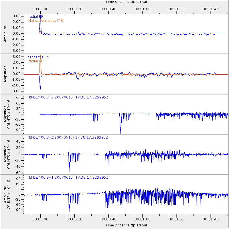
MSEY Mahe, Seychelles - Earthquake Result Viewer

| Earthquake location: |
Southeast Indian Ridge |
| Earthquake latitude/longitude: |
-46.4/96.0 |
| Earthquake time(UTC): |
2007/06/15 (166) 17:29:21 GMT |
| Earthquake Depth: |
10 km |
| Earthquake Magnitude: |
5.6 MW, 5.6 MW |
| Earthquake Catalog/Contributor: |
NEIC PDE/NEIC PDE-M |
|
| Network: |
II Global Seismograph Network (GSN - IRIS/IDA) |
| Station: |
MSEY Mahe, Seychelles |
| Lat/Lon: |
4.67 S/55.48 E |
| Elevation: |
475 m |
|
| Distance: |
54.3 deg |
| Az: |
307.157 deg |
| Baz: |
146.391 deg |
| Ray Param: |
0.06550626 |
| Estimated Moho Depth: |
48.75 km |
| Estimated Crust Vp/Vs: |
2.02 |
| Assumed Crust Vp: |
6.303 km/s |
| Estimated Crust Vs: |
3.12 km/s |
| Estimated Crust Poisson's Ratio: |
0.34 |
|
| Radial Match: |
97.058365 % |
| Radial Bump: |
206 |
| Transverse Match: |
91.62767 % |
| Transverse Bump: |
364 |
| SOD ConfigId: |
590571 |
| Insert Time: |
2013-09-26 12:17:24.719 +0000 |
| GWidth: |
2.5 |
| Max Bumps: |
400 |
| Tol: |
0.001 |
|
Signal To Noise
| Channel | StoN | STA | LTA |
| II:MSEY:00:BHZ:20070615T17:38:17.329995Z | 5.79589 | 3.5233427E-6 | 6.079037E-7 |
| II:MSEY:00:BH1:20070615T17:38:17.329995Z | 6.067119 | 1.1100191E-5 | 1.8295653E-6 |
| II:MSEY:00:BH2:20070615T17:38:17.329995Z | 14.682791 | 1.0484675E-5 | 7.1407914E-7 |
| Arrivals |
| Ps | 8.2 SECOND |
| PpPs | 22 SECOND |
| PsPs/PpSs | 31 SECOND |


