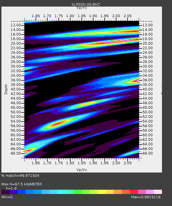
RSSD Black Hills, South Dakota, USA - Earthquake Result Viewer

Earthquake location: Fox Islands, Aleutian Islands
Earthquake latitude/longitude: 52.5/-168.0
Earthquake time(UTC): 2007/07/15 (196) 13:08:00 GMT
Earthquake Depth: 10 km
Earthquake Magnitude: 5.8 MB, 5.9 MS, 6.1 MW, 6.0 MW
Earthquake Catalog/Contributor: WHDF/NEIC
Network: IU Global Seismograph Network (GSN - IRIS/USGS)
Station: RSSD Black Hills, South Dakota, USA
Lat/Lon: 44.12 N/104.04 W
Elevation: 2060 m
Distance: 42.1 deg
Az: 74.904 deg
Baz: 304.923 deg
Ray Param: 0.0733656
Estimated Moho Depth: 67.5 km
Estimated Crust Vp/Vs: 1.60
Assumed Crust Vp: 6.242 km/s
Estimated Crust Vs: 3.901 km/s
Estimated Crust Poisson's Ratio: 0.18
Radial Match: 96.971504 %
Radial Bump: 221
Transverse Match: 81.68464 %
Transverse Bump: 400
SOD ConfigId: 590571
Insert Time: 2013-09-26 12:45:22.916 +0000
GWidth: 2.5
Max Bumps: 400
Tol: 0.001

Signal To Noise

ChannelStoNSTALTA
IU:RSSD:00:BHZ:20070715T13:15:22.135012Z8.3279185.0397904E-76.0516804E-8
IU:RSSD:00:BH1:20070715T13:15:22.135012Z5.1454462.8470546E-75.533154E-8
IU:RSSD:00:BH2:20070715T13:15:22.135012Z2.21574387.550697E-83.407748E-8
Arrivals
Ps7.0 SECOND
PpPs26 SECOND
PsPs/PpSs33 SECOND