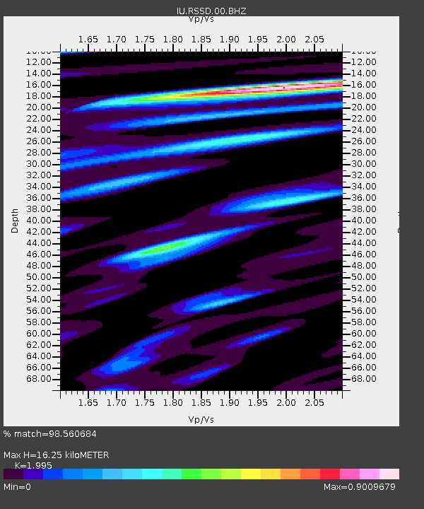
RSSD Black Hills, South Dakota, USA - Earthquake Result Viewer

Earthquake location: Near West Coast Of Honshu, Japan
Earthquake latitude/longitude: 37.5/138.4
Earthquake time(UTC): 2007/07/16 (197) 01:13:22 GMT
Earthquake Depth: 12 km
Earthquake Magnitude: 6.5 MB, 6.4 MS, 6.6 MW, 6.5 MW
Earthquake Catalog/Contributor: WHDF/NEIC
Network: IU Global Seismograph Network (GSN - IRIS/USGS)
Station: RSSD Black Hills, South Dakota, USA
Lat/Lon: 44.12 N/104.04 W
Elevation: 2060 m
Distance: 81.0 deg
Az: 40.292 deg
Baz: 314.455 deg
Ray Param: 0.047887616
Estimated Moho Depth: 16.25 km
Estimated Crust Vp/Vs: 2.00
Assumed Crust Vp: 6.242 km/s
Estimated Crust Vs: 3.129 km/s
Estimated Crust Poisson's Ratio: 0.33
Radial Match: 98.560684 %
Radial Bump: 287
Transverse Match: 94.532135 %
Transverse Bump: 400
SOD ConfigId: 590571
Insert Time: 2013-09-26 12:47:21.915 +0000
GWidth: 2.5
Max Bumps: 400
Tol: 0.001

Signal To Noise

ChannelStoNSTALTA
IU:RSSD:00:BHZ:20070716T01:25:05.435002Z80.1488653.3330066E-64.15852E-8
IU:RSSD:00:BH1:20070716T01:25:05.435002Z26.0785031.2425597E-64.76469E-8
IU:RSSD:00:BH2:20070716T01:25:05.435002Z2.67137551.3951077E-75.222432E-8
Arrivals
Ps2.7 SECOND
PpPs7.6 SECOND
PsPs/PpSs10 SECOND