You are here: Home > Network List > IU - Global Seismograph Network (GSN - IRIS/USGS) Stations List
> Station RSSD Black Hills, South Dakota, USA > Earthquake Result Viewer
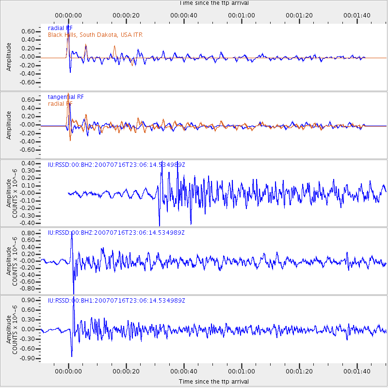
RSSD Black Hills, South Dakota, USA - Earthquake Result Viewer
*The percent match for this event was below the threshold and hence no stack was calculated.
| Earthquake location: |
Northern Colombia |
| Earthquake latitude/longitude: |
7.2/-72.1 |
| Earthquake time(UTC): |
2007/07/16 (197) 22:58:23 GMT |
| Earthquake Depth: |
30 km |
| Earthquake Magnitude: |
5.5 MB, 4.5 MS, 5.1 MW, 5.6 ML |
| Earthquake Catalog/Contributor: |
WHDF/NEIC |
|
| Network: |
IU Global Seismograph Network (GSN - IRIS/USGS) |
| Station: |
RSSD Black Hills, South Dakota, USA |
| Lat/Lon: |
44.12 N/104.04 W |
| Elevation: |
2060 m |
|
| Distance: |
46.1 deg |
| Az: |
328.135 deg |
| Baz: |
133.337 deg |
| Ray Param: |
$rayparam |
*The percent match for this event was below the threshold and hence was not used in the summary stack. |
|
| Radial Match: |
79.69008 % |
| Radial Bump: |
365 |
| Transverse Match: |
67.50007 % |
| Transverse Bump: |
400 |
| SOD ConfigId: |
590571 |
| Insert Time: |
2013-09-26 12:50:19.787 +0000 |
| GWidth: |
2.5 |
| Max Bumps: |
400 |
| Tol: |
0.001 |
|
Signal To Noise
| Channel | StoN | STA | LTA |
| IU:RSSD:00:BHZ:20070716T23:06:14.534989Z | 7.107306 | 3.338694E-7 | 4.697552E-8 |
| IU:RSSD:00:BH1:20070716T23:06:14.534989Z | 9.050336 | 3.3132264E-7 | 3.6608878E-8 |
| IU:RSSD:00:BH2:20070716T23:06:14.534989Z | 6.610921 | 1.7380134E-7 | 2.6290035E-8 |
| Arrivals |
| Ps | |
| PpPs | |
| PsPs/PpSs | |


