You are here: Home > Network List > TA - USArray Transportable Network (new EarthScope stations) Stations List
> Station G59A Clarenceville, QC, USA > Earthquake Result Viewer
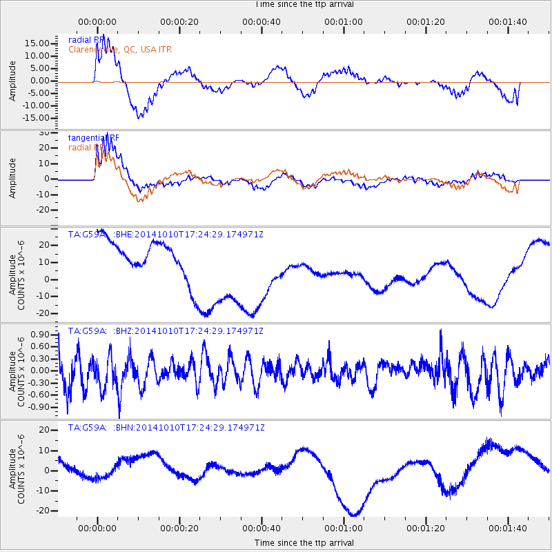
G59A Clarenceville, QC, USA - Earthquake Result Viewer
*The percent match for this event was below the threshold and hence no stack was calculated.
| Earthquake location: |
Southern East Pacific Rise |
| Earthquake latitude/longitude: |
-32.7/-111.7 |
| Earthquake time(UTC): |
2014/10/10 (283) 17:12:25 GMT |
| Earthquake Depth: |
10 km |
| Earthquake Magnitude: |
5.2 MW |
| Earthquake Catalog/Contributor: |
ISC/ISC |
|
| Network: |
TA USArray Transportable Network (new EarthScope stations) |
| Station: |
G59A Clarenceville, QC, USA |
| Lat/Lon: |
45.08 N/73.18 W |
| Elevation: |
36 m |
|
| Distance: |
85.0 deg |
| Az: |
26.314 deg |
| Baz: |
211.841 deg |
| Ray Param: |
$rayparam |
*The percent match for this event was below the threshold and hence was not used in the summary stack. |
|
| Radial Match: |
61.593224 % |
| Radial Bump: |
400 |
| Transverse Match: |
78.930756 % |
| Transverse Bump: |
400 |
| SOD ConfigId: |
3390531 |
| Insert Time: |
2019-04-14 11:23:38.058 +0000 |
| GWidth: |
2.5 |
| Max Bumps: |
400 |
| Tol: |
0.001 |
|
Signal To Noise
| Channel | StoN | STA | LTA |
| TA:G59A: :BHZ:20141010T17:24:29.174971Z | 1.272353 | 3.9972798E-7 | 3.1416437E-7 |
| TA:G59A: :BHN:20141010T17:24:29.174971Z | 0.5064596 | 3.1518189E-6 | 6.2232384E-6 |
| TA:G59A: :BHE:20141010T17:24:29.174971Z | 2.216721 | 2.5103123E-5 | 1.132444E-5 |
| Arrivals |
| Ps | |
| PpPs | |
| PsPs/PpSs | |


