You are here: Home > Network List > TA - USArray Transportable Network (new EarthScope stations) Stations List
> Station L59A Walton, NY, USA > Earthquake Result Viewer
L59A Walton, NY, USA - Earthquake Result Viewer
| Earthquake location: |
Southern East Pacific Rise |
| Earthquake latitude/longitude: |
-32.7/-111.7 |
| Earthquake time(UTC): |
2014/10/10 (283) 17:12:25 GMT |
| Earthquake Depth: |
10 km |
| Earthquake Magnitude: |
5.2 MW |
| Earthquake Catalog/Contributor: |
ISC/ISC |
|
| Network: |
TA USArray Transportable Network (new EarthScope stations) |
| Station: |
L59A Walton, NY, USA |
| Lat/Lon: |
42.19 N/75.04 W |
| Elevation: |
677 m |
|
| Distance: |
81.8 deg |
| Az: |
26.658 deg |
| Baz: |
210.6 deg |
| Ray Param: |
0.047333755 |
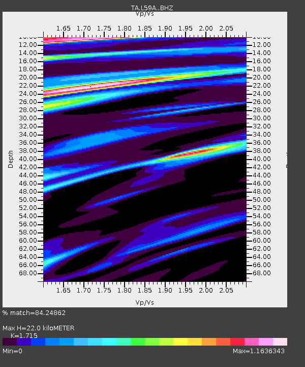
| Estimated Moho Depth: |
22.0 km |
| Estimated Crust Vp/Vs: |
1.72 |
| Assumed Crust Vp: |
6.419 km/s |
| Estimated Crust Vs: |
3.743 km/s |
| Estimated Crust Poisson's Ratio: |
0.24 |
|
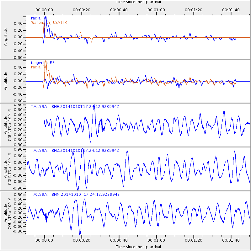
| Radial Match: |
84.24862 % |
| Radial Bump: |
400 |
| Transverse Match: |
49.2279 % |
| Transverse Bump: |
306 |
| SOD ConfigId: |
3390531 |
| Insert Time: |
2019-04-14 11:23:50.146 +0000 |
| GWidth: |
2.5 |
| Max Bumps: |
400 |
| Tol: |
0.001 |
|
Signal To Noise
| Channel | StoN | STA | LTA |
| TA:L59A: :BHZ:20141010T17:24:12.923994Z | 0.92777 | 1.8609303E-7 | 2.0058098E-7 |
| TA:L59A: :BHN:20141010T17:24:12.923994Z | 0.7208376 | 1.2840766E-7 | 1.7813674E-7 |
| TA:L59A: :BHE:20141010T17:24:12.923994Z | 0.79788053 | 1.8259604E-7 | 2.2885135E-7 |
| Arrivals |
| Ps | 2.5 SECOND |
| PpPs | 9.0 SECOND |
| PsPs/PpSs | 12 SECOND |


