You are here: Home > Network List > TA - USArray Transportable Network (new EarthScope stations) Stations List
> Station N53A Lisbon, OH, USA > Earthquake Result Viewer
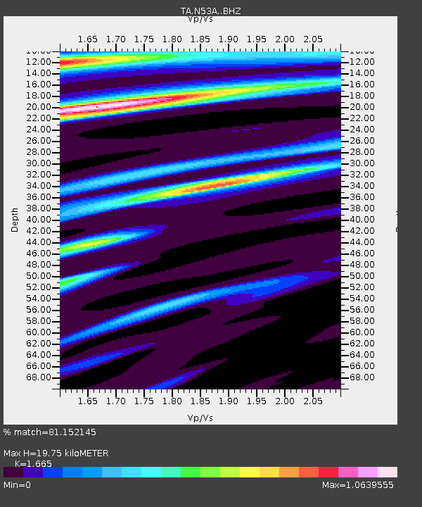
N53A Lisbon, OH, USA - Earthquake Result Viewer
| Earthquake location: |
Southern East Pacific Rise |
| Earthquake latitude/longitude: |
-32.7/-111.7 |
| Earthquake time(UTC): |
2014/10/10 (283) 17:12:25 GMT |
| Earthquake Depth: |
10 km |
| Earthquake Magnitude: |
5.2 MW |
| Earthquake Catalog/Contributor: |
ISC/ISC |
|
| Network: |
TA USArray Transportable Network (new EarthScope stations) |
| Station: |
N53A Lisbon, OH, USA |
| Lat/Lon: |
40.81 N/80.84 W |
| Elevation: |
360 m |
|
| Distance: |
78.5 deg |
| Az: |
23.44 deg |
| Baz: |
206.222 deg |
| Ray Param: |
0.049591552 |
| Estimated Moho Depth: |
19.75 km |
| Estimated Crust Vp/Vs: |
1.66 |
| Assumed Crust Vp: |
6.483 km/s |
| Estimated Crust Vs: |
3.893 km/s |
| Estimated Crust Poisson's Ratio: |
0.22 |
|
| Radial Match: |
81.152145 % |
| Radial Bump: |
400 |
| Transverse Match: |
55.33936 % |
| Transverse Bump: |
400 |
| SOD ConfigId: |
3390531 |
| Insert Time: |
2019-04-14 11:23:57.077 +0000 |
| GWidth: |
2.5 |
| Max Bumps: |
400 |
| Tol: |
0.001 |
|

Signal To Noise
| Channel | StoN | STA | LTA |
| TA:N53A: :BHZ:20141010T17:23:55.249983Z | 2.8618486 | 7.635585E-7 | 2.6680604E-7 |
| TA:N53A: :BHN:20141010T17:23:55.249983Z | 1.2532463 | 3.205053E-7 | 2.5574008E-7 |
| TA:N53A: :BHE:20141010T17:23:55.249983Z | 1.6390657 | 3.3397586E-7 | 2.037599E-7 |
| Arrivals |
| Ps | 2.1 SECOND |
| PpPs | 7.9 SECOND |
| PsPs/PpSs | 10.0 SECOND |


